Approximate Location Map
Large Map »
Latitude: 51.4437 / 51°26'37"N
Longitude: -0.0733 / 0°4'23"W
OS Eastings: 533996
OS Northings: 173396
OS Grid: TQ339733
Mapcode National: GBR HL.XW4
Mapcode Global: VHGR6.PZ34
Plus Code: 9C3XCWVG+FM
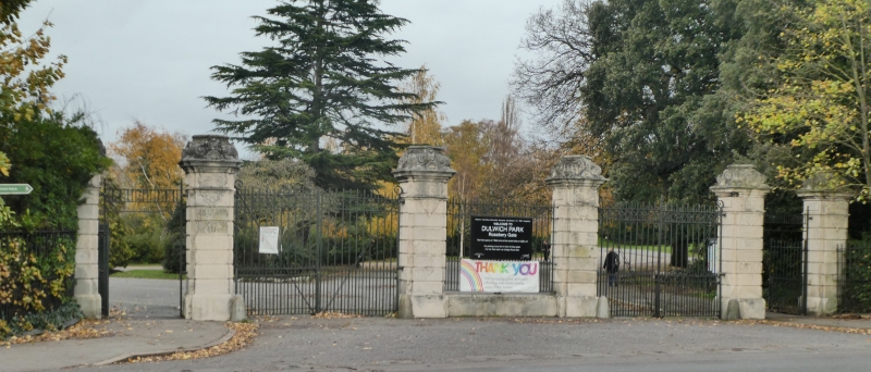
Entry Name: Roseberry Gate to Dulwich Park and Attached Railings
Listing Date: 17 September 1998
Grade: II
Source: Historic England
Source ID: 1385474
English Heritage Legacy ID: 470873
ID on this website: 101385474
Location: Dulwich Park, East Dulwich, Southwark, London, SE21
County: London
District: Southwark
Electoral Ward/Division: College
Parish: Non Civil Parish
Built-Up Area: Southwark
Traditional County: Surrey
Lieutenancy Area (Ceremonial County): Greater London
Church of England Parish: Dulwich St Clement with St Peter
Church of England Diocese: Southwark
Tagged with: Gate Architectural structure
SOUTHWARK
TQ3373 DULWICH COMMON
636-1/15/289 (South side)
Roseberry Gate to Dulwich Park and
attached railings
GV II
Gate. c1890. Stone, cast- and wrought-iron. 6 piers defining 2
carriageways, flanked by walkways; the centre pair define a
central reserve, the railings debouch to the line of pavement
and terminate in one pier at either end.
Each pier of identical description and similar to those on the
Old College Gate, College Road (qv), Queen Mary Gate, Dulwich
Common (qv) and Court Lane Gate (qv): square, rebated in
section; rusticated blocks to capital formed from plaques;
capstone of scrolls and volutes inspired by French Second
Empire designs. Gates with ornamental cresting.
Forms a group with Roseberry Lodge (qv).
Listing NGR: TQ3399673396
External links are from the relevant listing authority and, where applicable, Wikidata. Wikidata IDs may be related buildings as well as this specific building. If you want to add or update a link, you will need to do so by editing the Wikidata entry.


Other nearby listed buildings
