Approximate Location Map
Large Map »
Latitude: 51.4428 / 51°26'34"N
Longitude: -0.0674 / 0°4'2"W
OS Eastings: 534407
OS Northings: 173304
OS Grid: TQ344733
Mapcode National: GBR HL.ZLF
Mapcode Global: VHGR6.SZ6V
Plus Code: 9C3XCWVM+42
Entry Name: St Peters Parish Hall
Listing Date: 22 February 1985
Grade: II
Source: Historic England
Source ID: 1385671
English Heritage Legacy ID: 471075
ID on this website: 101385671
Location: St Peter's Church, Southwark, London, SE22
County: London
District: Southwark
Electoral Ward/Division: College
Parish: Non Civil Parish
Built-Up Area: Southwark
Traditional County: Surrey
Lieutenancy Area (Ceremonial County): Greater London
Church of England Parish: Dulwich St Clement with St Peter
Church of England Diocese: Southwark
Tagged with: Architectural structure
SOUTHWARK
TQ3473SW LORDSHIP LANE
636-1/70/494 (South West side)
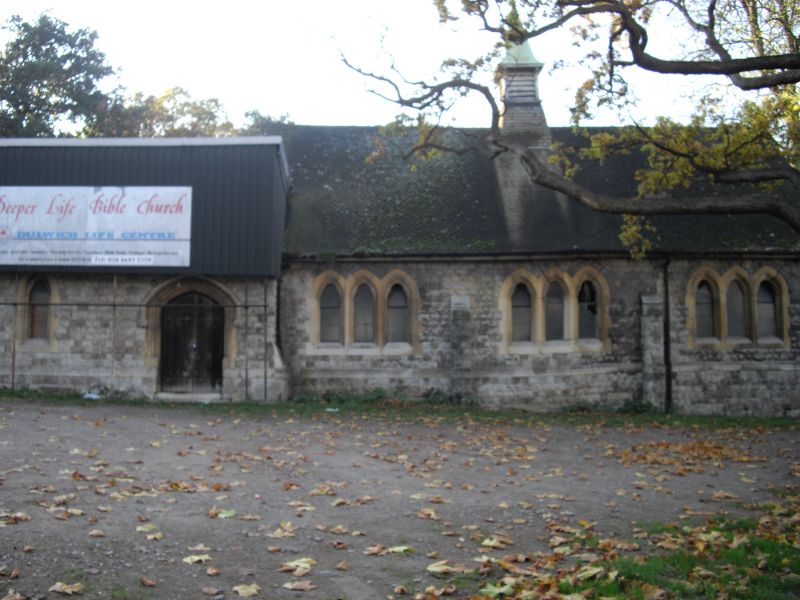
22/02/85 St Peter's Parish Hall
GV II
Parish hall. After 1897. Probably by Charles Barry Jnr.
Kentish ragstone with ashlar dressings; steeply pitched tiled
roof with louvred fleche for bell with copper spirelet.
3 bays, each with cusped triplet windows; single-storey. 2-bay
later extension to east. Open timber roof. Now used for
storage.
INTERIOR: not inspected.
Included for group value with the Church of St Peter (qv).
Listing NGR: TQ3440773304
External links are from the relevant listing authority and, where applicable, Wikidata. Wikidata IDs may be related buildings as well as this specific building. If you want to add or update a link, you will need to do so by editing the Wikidata entry.


Other nearby listed buildings
