Approximate Location Map
Large Map »
Latitude: 51.4656 / 51°27'56"N
Longitude: -0.0843 / 0°5'3"W
OS Eastings: 533166
OS Northings: 175806
OS Grid: TQ331758
Mapcode National: GBR TX.6T
Mapcode Global: VHGR6.HF8B
Plus Code: 9C3XFW88+67
Entry Name: 201, Grove Lane
Listing Date: 17 July 1970
Last Amended: 17 September 1998
Grade: II
Source: Historic England
Source ID: 1385587
English Heritage Legacy ID: 470990
ID on this website: 101385587
Location: Southwark, London, SE5
County: London
District: Southwark
Electoral Ward/Division: South Camberwell
Parish: Non Civil Parish
Built-Up Area: Southwark
Traditional County: Surrey
Lieutenancy Area (Ceremonial County): Greater London
Church of England Parish: Camberwell St Giles with St Matthew
Church of England Diocese: Southwark
Tagged with: Building
SOUTHWARK
TQ3375NW GROVE LANE
636-1/46/412 (East side)
17/07/70 No.201
(Formerly Listed as:
GROVE LANE
(East side)
Nos.197, 199 AND 201)
GV II
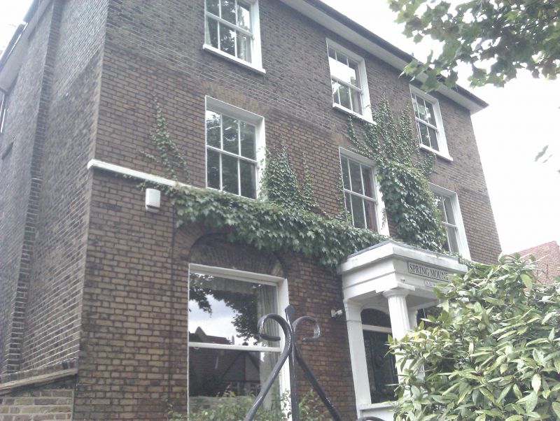
Detached house. 1824. Brick with some stucco; hipped slate
roof with eaves soffit.
3 storeys and stucco basement, 3 bays. Central Greek Doric
stucco porch, door under elliptical arch with decorative
fanlight. Sash windows have flat, gauged-brick arches, those
on ground floor replaced and larger with elliptical arch above
each; those on upper floors with glazing bars. 1st-floor sill
band.
INTERIOR: not inspected.
Listing NGR: TQ3316675806
External links are from the relevant listing authority and, where applicable, Wikidata. Wikidata IDs may be related buildings as well as this specific building. If you want to add or update a link, you will need to do so by editing the Wikidata entry.


Other nearby listed buildings
