Approximate Location Map
Large Map »
Latitude: 51.4917 / 51°29'30"N
Longitude: -0.0818 / 0°4'54"W
OS Eastings: 533264
OS Northings: 178717
OS Grid: TQ332787
Mapcode National: GBR TM.RF
Mapcode Global: VHGR0.JRLT
Plus Code: 9C3XFWR9+M7
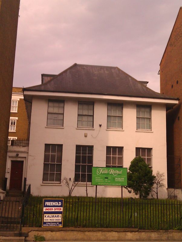
Entry Name: The White House
Listing Date: 27 September 1972
Grade: II
Source: Historic England
Source ID: 1385736
English Heritage Legacy ID: 471146
ID on this website: 101385736
Location: Walworth, Southwark, London, SE1
County: London
District: Southwark
Electoral Ward/Division: Grange
Parish: Non Civil Parish
Built-Up Area: Southwark
Traditional County: Surrey
Lieutenancy Area (Ceremonial County): Greater London
Church of England Parish: Walworth St Christopher
Church of England Diocese: Southwark
Tagged with: House
SOUTHWARK
TQ3378 OLD KENT ROAD
636-1/8/544 (North side)
27/09/72 No.155
The White House
GV II
House and office, now office. 1800. By Michael Searle, for
himself. Stucco with swept hipped slate roof. Set back from
road.
2 storeys, 4 bays with 1-storey, 1-bay extension to left
containing entrance in square-headed recess with key. Sash
windows with glazing bars in plain reveals. Deep, overhanging
eaves band.
INTERIOR: not inspected.
HISTORICAL NOTE: built as Searle's own house and office.
Listing NGR: TQ3326478716
External links are from the relevant listing authority and, where applicable, Wikidata. Wikidata IDs may be related buildings as well as this specific building. If you want to add or update a link, you will need to do so by editing the Wikidata entry.


Other nearby listed buildings
