Approximate Location Map
Large Map »
Latitude: 51.5013 / 51°30'4"N
Longitude: -0.0546 / 0°3'16"W
OS Eastings: 535126
OS Northings: 179832
OS Grid: TQ351798
Mapcode National: GBR JB.2X4
Mapcode Global: VHGR1.0JHG
Plus Code: 9C3XGW2W+G5
Entry Name: Hope Sufferance Wharf
Listing Date: 1 July 1983
Grade: II
Source: Historic England
Source ID: 1385869
English Heritage Legacy ID: 471288
ID on this website: 101385869
Location: Rotherhithe, Southwark, London, SE16
County: London
District: Southwark
Electoral Ward/Division: Rotherhithe
Parish: Non Civil Parish
Built-Up Area: Southwark
Traditional County: Surrey
Lieutenancy Area (Ceremonial County): Greater London
Church of England Parish: Rotherhithe St Mary with All Saints
Church of England Diocese: Southwark
Tagged with: Architectural structure
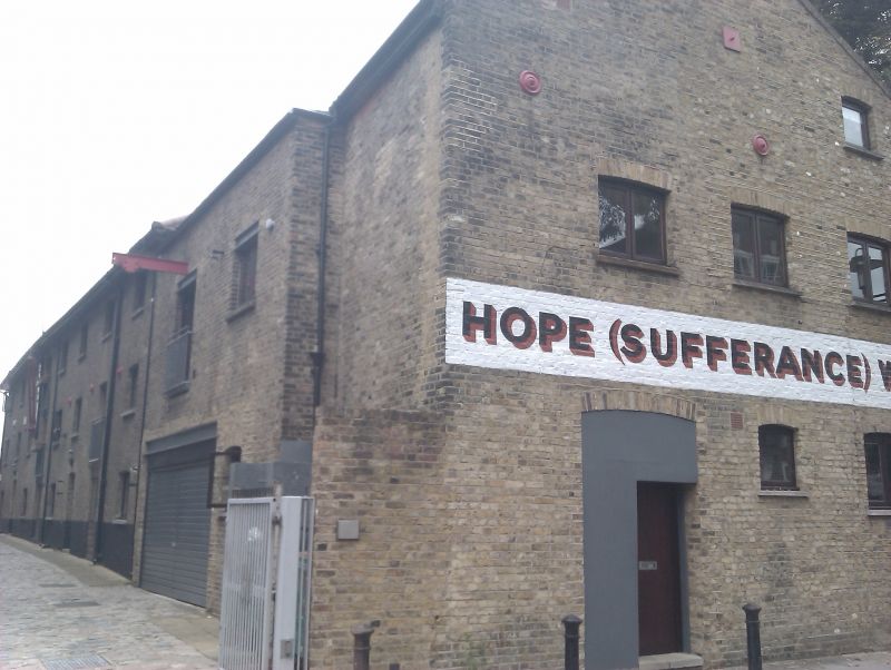
SOUTHWARK
TQ3579 ST MARYCHURCH STREET
636-1/6/731 (North side)
01/07/83 Hope Sufferance Wharf
GV II
Grain warehouse and workshop, later studio workshops, now
flats. Late C18-early C19. Yellow stock brick with pitched
pantiled roof (largely renewed and with dormers) with gable
ends to street. Warehouse and workshop ranges on opposite
sides of yard. Warehouse range to east of 3 storeys (and
attic), 3 bays to street. Small camber-arched windows.
Workshop range to west has smaller gabled front of 1 bay to
street.
INTERIOR: timber construction with at least 1 post a reused
ship's timber, part of a mast.
Early warehouse survival.
Listing NGR: TQ3512679832
External links are from the relevant listing authority and, where applicable, Wikidata. Wikidata IDs may be related buildings as well as this specific building. If you want to add or update a link, you will need to do so by editing the Wikidata entry.


Other nearby listed buildings
