Approximate Location Map
Large Map »
Latitude: 51.5046 / 51°30'16"N
Longitude: -0.0909 / 0°5'27"W
OS Eastings: 532594
OS Northings: 180131
OS Grid: TQ325801
Mapcode National: GBR RG.QT
Mapcode Global: VHGR0.CFSY
Plus Code: 9C3XGW35+RJ
Entry Name: 3, Southwark Street
Listing Date: 17 September 1998
Grade: II
Source: Historic England
Source ID: 1385922
English Heritage Legacy ID: 471342
ID on this website: 101385922
Location: The Borough, Southwark, London, SE1
County: London
District: Southwark
Electoral Ward/Division: Cathedrals
Parish: Non Civil Parish
Built-Up Area: Southwark
Traditional County: Surrey
Lieutenancy Area (Ceremonial County): Greater London
Church of England Parish: St Saviour with All Hallows Southwark
Church of England Diocese: Southwark
Tagged with: Building
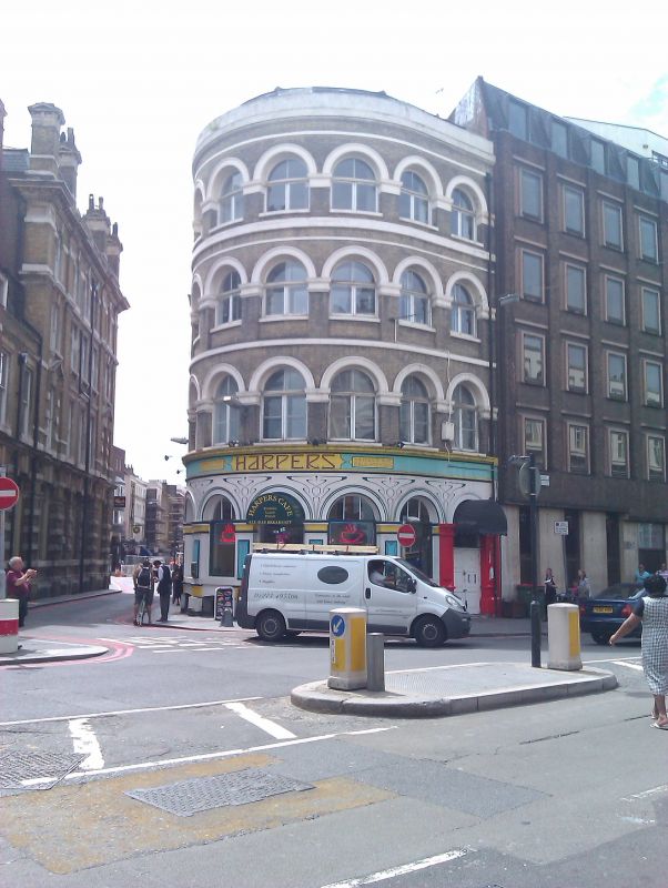
SOUTHWARK
TQ3280SE SOUTHWARK STREET
636-1/17/706 (South side)
No.3
II
Warehouse. 1864-5. Stock brick with stucco dressings, and
slate mansard roof with dormers set back behind parapet.
Curving corner plan with eight-window range including return
with 3 windows and hoist range. Italianate style.
4 storeys over basement. Round-headed windows forming a
continuous arcade to each storey. With the exception of the
ground-floor where the lower part of the openings have been
filled with plate glass, almost all the remaining openings
have authentic glazing which consists of casements with
fixed-arched lights above.
All 3 doors are of C20 date. The openings of the hoist range,
the iron bracket with pulley, and the hatch of the topmost
doorway are all authentic.
INTERIOR: not inspected.
HISTORICAL NOTE: one of the first buildings to be erected in
Southwark Street, forming an excellent 'gateway' to the newly
opened commercial thoroughfare laid out by the Metropolitan
Board of Works to link London Bridge and Blackfriars.
Southwark Street was the Board's first town-planning
initiative, and was opened along its entire length in 1864.
No.3 appears in a view of the street which was published in
the "Illustrated London News" for 18 February 1865.
Listing NGR: TQ3259480131
External links are from the relevant listing authority and, where applicable, Wikidata. Wikidata IDs may be related buildings as well as this specific building. If you want to add or update a link, you will need to do so by editing the Wikidata entry.


Other nearby listed buildings
