Approximate Location Map
Large Map »
Latitude: 50.3674 / 50°22'2"N
Longitude: -4.1348 / 4°8'5"W
OS Eastings: 248272
OS Northings: 54124
OS Grid: SX482541
Mapcode National: GBR RCK.6G
Mapcode Global: FRA 2872.6ZG
Plus Code: 9C2Q9V88+X3
Entry Name: The Navy Public House
Listing Date: 1 May 1975
Last Amended: 9 November 1998
Grade: II
Source: Historic England
Source ID: 1386402
English Heritage Legacy ID: 473788
Also known as: Navy Inn
ID on this website: 101386402
Location: Barbican, Plymouth, Devon, PL1
County: City of Plymouth
Electoral Ward/Division: St Peter and the Waterfront
Parish: Non Civil Parish
Built-Up Area: Plymouth
Traditional County: Devon
Lieutenancy Area (Ceremonial County): Devon
Tagged with: Pub
PLYMOUTH
SX4854SW SOUTHSIDE STREET, Barbican
740-1/62/65 (North side)
01/05/75 No.34
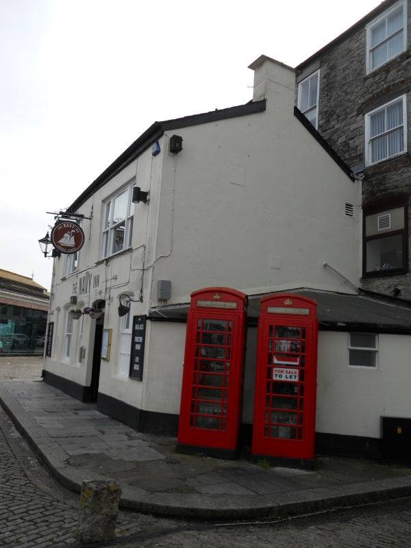
The Navy Public House
(Formerly Listed as:
SOUTHSIDE STREET, Plymouth
The Navy Public House)
GV II
Public house. Probably late C18. Render on brick front with
stucco mid-floor bands; steep dry slate roofs with rendered
end stacks. Double-depth plan plus 2-storey range parallel to
rear right.
4 storeys; symmetrical 3-window front. Late C19 or C20 horned
sashes: tripartite sashes to side bays, those to 1st and 2nd
floors under segmental arches. Ground floor has full-width
fascia with moulded cornice and central open pediment to
doorway, with overlight and old 6-panel door, flanked by
triple sashes. Rear has sashes, some with horns, some without.
INTERIOR: not inspected.
Listing NGR: SX4827254124
External links are from the relevant listing authority and, where applicable, Wikidata. Wikidata IDs may be related buildings as well as this specific building. If you want to add or update a link, you will need to do so by editing the Wikidata entry.


Other nearby listed buildings
