Approximate Location Map
Large Map »
Latitude: 51.9048 / 51°54'17"N
Longitude: -2.0723 / 2°4'20"W
OS Eastings: 395124
OS Northings: 222916
OS Grid: SO951229
Mapcode National: GBR 2M4.JX9
Mapcode Global: VHB1Q.1DB4
Plus Code: 9C3VWW3H+W3
Entry Name: Camden House
Listing Date: 5 May 1972
Last Amended: 26 November 1998
Grade: II
Source: Historic England
Source ID: 1386844
English Heritage Legacy ID: 474255
ID on this website: 101386844
Location: Cheltenham, Gloucestershire, GL50
County: Gloucestershire
District: Cheltenham
Electoral Ward/Division: Pittville
Parish: Non Civil Parish
Built-Up Area: Cheltenham
Traditional County: Gloucestershire
Lieutenancy Area (Ceremonial County): Gloucestershire
Church of England Parish: Cheltenham St Paul
Church of England Diocese: Gloucester
Tagged with: House
CHELTENHAM
SO9522NW CLARENCE ROAD
630-1/10/259 (North side)
05/05/72 Camden House
(Formerly Listed as:
CLARENCE SQUARE
(East side)
Holy Trinity Vicarage)
GV II
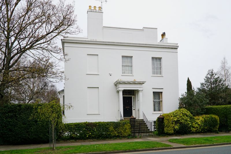
Villa. 1834-5. Stucco over brick with flat-topped hipped slate
roof and end stucco stacks.
EXTERIOR: 2 storeys on basement, 3 first-floor windows and
with service range set back to right. First floor has 6/6
sashes. Ground floor has 1/1 sashes, the two to right have
blind boxes; all windows in plain reveals and with sills.
Central entrance in distyle mutular Doric porch with triglyphs
and metopes. Frieze, cornice, blocking course; stacks
incorporated in raised parapet. Garden facade (west, to
Clarence Square): 3-window range. first floor has 6/6 sashes
in tooled architraves, otherwise 1/1 sashes and Victorian bay
with tripartite 1/1 sashes. Attic to north.
INTERIOR: noted as retaining original joinery, including
shutters.
SUBSIDIARY FEATURES: window guards to ground floor, west
facade. Blind boxes to ground floor, right of main facade.
HISTORICAL NOTE: built as part of the development of this area
undertaken for Joseph Pitt in 1825-42, the general layout
being designed by the architect John Forbes. Clarence Square
was laid out in the late 1820s, building began in 1832. This
was the vicarage for Church of the Holy Trinity, Portland
Street (qv). The Square was named after the Duke of Clarence,
who became William IV in 1830.
Occupies a corner site at the junction of Clarence Square and
Clarence Road.
(Blake S: Pittville: 1824-1860: Cheltenham: 1988-: 37,58).
Listing NGR: SO9512522918
External links are from the relevant listing authority and, where applicable, Wikidata. Wikidata IDs may be related buildings as well as this specific building. If you want to add or update a link, you will need to do so by editing the Wikidata entry.


Other nearby listed buildings
