Approximate Location Map
Large Map »
Latitude: 52.1119 / 52°6'42"N
Longitude: -2.0757 / 2°4'32"W
OS Eastings: 394914
OS Northings: 245952
OS Grid: SO949459
Mapcode National: GBR 2JM.J23
Mapcode Global: VH938.Z51W
Plus Code: 9C4V4W6F+PP
Entry Name: 49 and 51, High Street
Listing Date: 3 August 1972
Last Amended: 30 March 1999
Grade: II
Source: Historic England
Source ID: 1387084
English Heritage Legacy ID: 474500
ID on this website: 101387084
Location: Pershore, Wychavon, Worcestershire, WR10
County: Worcestershire
District: Wychavon
Civil Parish: Pershore
Built-Up Area: Pershore
Traditional County: Worcestershire
Lieutenancy Area (Ceremonial County): Worcestershire
Church of England Parish: Pershore
Church of England Diocese: Worcester
Tagged with: Building
PERSHORE
SO9445 HIGH STREET
648-1/5/141 (East side)
03/08/72 Nos.49 AND 51
(Formerly Listed as:
HIGH STREET
(East side)
No.49 (Ship Inn) & No.51)
GV II
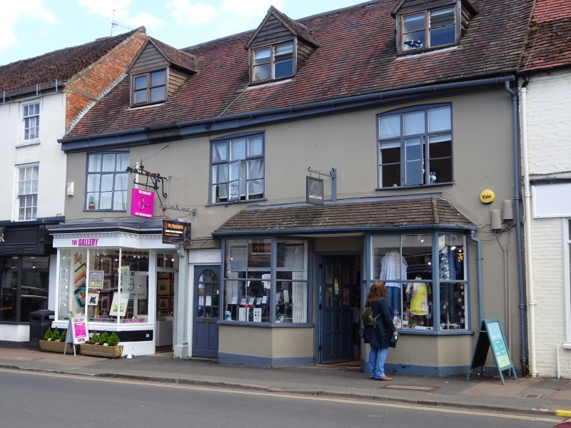
House, part formerly an inn, now 2 shops and offices. Late
C18-early C19 incorporating earlier, probably C17 work, and
with later alterations. Brick rendered with lined stucco.
Renewed plain tile roof with 3 gabled dormers.
EXTERIOR: 2 storeys; 3-window range with three parallel rear
wings at right-angles, that on right (to No.51) extending
further. Main range: first floor has 9-pane segmental-headed
windows each with one central casement and some further
top-hung casements. Ground floor: right-hand shopfront C20
with central part-glazed door flanked by plate-glazed
canted-bay windows, all under pitched tile roof.
Left-hand shop front has leaded modillion cornice; fascia;
pilaster on right below bracketed gablet; plate glass
shop-window with canted corner, 3 moulded mullions and moulded
sill; C20 shop door to right side, within passage; and 4-panel
door to through-passage.
Rear: main wing has stack, old tile roof, part dentilled
eaves; two further gabled wings with old tile roofs.
INTERIOR: not inspected.
HISTORICAL NOTE: the right-hand part of the building was the
former Ship Inn, and the 1st floor of the left-hand part
housed a former Masons' lodge.
Listing NGR: SO9491445952
External links are from the relevant listing authority and, where applicable, Wikidata. Wikidata IDs may be related buildings as well as this specific building. If you want to add or update a link, you will need to do so by editing the Wikidata entry.


Other nearby listed buildings
