Approximate Location Map
Large Map »
Latitude: 51.892 / 51°53'31"N
Longitude: -2.0835 / 2°5'0"W
OS Eastings: 394352
OS Northings: 221498
OS Grid: SO943214
Mapcode National: GBR 2MB.830
Mapcode Global: VH947.TPXY
Plus Code: 9C3VVWR8+RJ
Entry Name: Napier House and Attached Wall and Pier
Listing Date: 5 May 1972
Last Amended: 26 November 1998
Grade: II
Source: Historic England
Source ID: 1387965
English Heritage Legacy ID: 475960
ID on this website: 101387965
Location: Montpellier, Cheltenham, Gloucestershire, GL50
County: Gloucestershire
District: Cheltenham
Electoral Ward/Division: Park
Parish: Non Civil Parish
Built-Up Area: Cheltenham
Traditional County: Gloucestershire
Lieutenancy Area (Ceremonial County): Gloucestershire
Church of England Parish: Leckhampton St Philip and St James
Church of England Diocese: Gloucester
Tagged with: Architectural structure
CHELTENHAM
SO9421NW SUFFOLK ROAD
630-1/17/866 (South side)
05/05/72 No.74
Napier House and attached wall and
pier
(Formerly Listed as:
SUFFOLK ROAD
No.74 (Even))
(Formerly Listed as:
PARK PLACE
(West side)
No.1)
GV II
Formerly known as: Nos.1 AND 2 ANDOVER PLACE.
Includes: No.1 PARK PLACE.
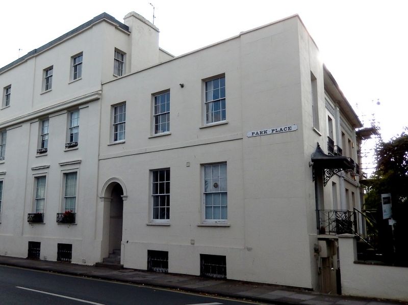
2 houses, now house at left and offices to right with attached
wall and pier. c1820-34. Stucco over brick with hipped slate
roof to centre part, ridge stucco stacks and end brick stacks;
wrought-iron balconies and porch. Pinkish-brown brick wall and
stucco pier.
EXTERIOR: 2 storeys on basements and with attics, 6
first-floor windows (arranged 1:4:1). Stucco detailing
includes pilasters to ends of main range and to party-wall
with sunk panels; first-floor band with foliate decoration;
friezes with scroll decoration. Wide eaves. 6/6 sashes
throughout (including to basement) in plain reveals and with
sills. End entrances, that to right set back beneath first
floor, have French windows to left and 5-panel, part-glazed
door with sidelights and overlight to right. Recess at right
has Doric pilasters. Attic roof dormer has casement windows,
otherwise skylight. Left return has 3 first-floor windows.
First-floor band; low parapet and copings. 6/6 sashes.
Entrance at end, round-arched opening with embellished
imposts, within a flight of curved steps to 6-panel
double-doors, fanlight with decorative glazing to its left.
INTERIOR: not inspected.
SUBSIDIARY FEATURES: individual first-floor balconies have
embellished rods. Ground floor to left has long balcony with
web motif and further balcony with scrolled lozenge motif.
Porch to left has tent roof and anthemion brackets. Chatwin
regards the long balcony at No.1, Park Place as 'outstanding'.
Wall approx 5m long with rusticated pier on chamfered plinth
and with dentil cornice and pineapple finial.
HISTORICAL NOTE: Shown as Andover Place on Merrett's Map of
1834. Suffolk Road is shown on Merrett's 1834 Map as
Commercial Street.
Forms a similar pair with Nos 76 and 78 Suffolk Place (qv) and
abuts Tunstall House, No.3 Park Place (qv) to rear.
(Chatwin A: Cheltenham's Ornamental Ironwork: Cheltenham:
1975-1984: 34; Merrett HS: Plan of the Town of Cheltenham:
1834-).
Listing NGR: SO9434421495
External links are from the relevant listing authority and, where applicable, Wikidata. Wikidata IDs may be related buildings as well as this specific building. If you want to add or update a link, you will need to do so by editing the Wikidata entry.


Other nearby listed buildings
