Latitude: 51.9012 / 51°54'4"N
Longitude: -2.0774 / 2°4'38"W
OS Eastings: 394769
OS Northings: 222519
OS Grid: SO947225
Mapcode National: GBR 2M4.PLL
Mapcode Global: VH947.YG3X
Plus Code: 9C3VWW2F+F2
Entry Name: Norfolk House
Listing Date: 14 December 1983
Grade: II
Source: Historic England
Source ID: 1388183
English Heritage Legacy ID: 476181
ID on this website: 101388183
Location: Cheltenham, Gloucestershire, GL50
County: Gloucestershire
District: Cheltenham
Electoral Ward/Division: Lansdown
Parish: Non Civil Parish
Built-Up Area: Cheltenham
Traditional County: Gloucestershire
Lieutenancy Area (Ceremonial County): Gloucestershire
Church of England Parish: Cheltenham, St Mary with St Matthew
Church of England Diocese: Gloucester
Tagged with: House
CHELTENHAM
SO9422NE WELL WALK 630-1/9/982 (West side) 14/12/83 No.8 Norfolk House
GV II
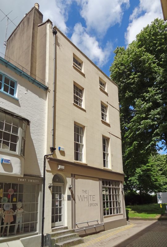
Also known as: Norfolk House CHESTER WALK. House, now restaurant. 1830s with later alterations, including c1970s ground-floor shop fronts. Stucco over brick with concealed roof. EXTERIOR: 4 storeys, 2+1 first-floor windows, that to right at angle and curved on plan and lower 4-storey, single-bay service range to rear at right. Stucco detailing includes frieze and cornice over ground floor; crowning low parapet with copings. First and second floors have 6/6 sashes, taller to first floor, third floor has 3/3 sashes, where original; all in plain reveals and with sills; windows to angle curved on section. Entrance to angle, 3 steps to C20 multi-pane glazed door. Further entrance to left, steps to C20 glazed door with overlight. Ground floor has plinth; multi-pane window and continuous frieze with cornice. Right return has 2 + 1 first-floor windows; stucco detailing continues to main range. First floor has blind opening at left, otherwise 6/6 sashes; second floor has two 6/6 sashes and 3/6 sash; third floor has 3/3 sashes. Similar ground-floor shop fronts. INTERIOR: not inspected. HISTORICAL NOTE: Well Walk (or Old Well Walk as it was known in the C19) was laid out by Andrews (the town surveyor) in 1743 to designs supplied by Norborne Berkeley, as a long avenue of elms extending for over 900 yards past Henry Skillicorne's original Pump Room and Well to the lower part of what is now Bayshill Road. As such, this Walk is an important survival of the C18 spa town development and frames one of the entrance ways to the parish Church of St Mary, Church Street (qv). (Little B: Cheltenham: London: 1952-: 34).
Listing NGR: SO9476322518
External links are from the relevant listing authority and, where applicable, Wikidata. Wikidata IDs may be related buildings as well as this specific building. If you want to add or update a link, you will need to do so by editing the Wikidata entry.


Other nearby listed buildings