Approximate Location Map
Large Map »
Latitude: 52.1886 / 52°11'18"N
Longitude: -2.2334 / 2°14'0"W
OS Eastings: 384142
OS Northings: 254509
OS Grid: SO841545
Mapcode National: GBR 1G4.L6G
Mapcode Global: VH92T.78N2
Plus Code: 9C4V5QQ8+CM
Entry Name: 1, St Johns
Listing Date: 20 September 1973
Grade: II
Source: Historic England
Source ID: 1390099
English Heritage Legacy ID: 489069
ID on this website: 101390099
Location: St John's, Worcester, Worcestershire, WR2
County: Worcestershire
District: Worcester
Electoral Ward/Division: Bedwardine
Parish: Non Civil Parish
Built-Up Area: Worcester
Traditional County: Worcestershire
Lieutenancy Area (Ceremonial County): Worcestershire
Church of England Parish: St John in Bedwardine
Church of England Diocese: Worcester
Tagged with: Building
This list entry was subject to a Minor Amendment on 18/10/2016
SO8454NW
620-1/15/564
WORCESTER
ST JOHNS (South side)
No.1
(Formerly listed as No 1, ST JOHN'S)
20/09/73
GV
II
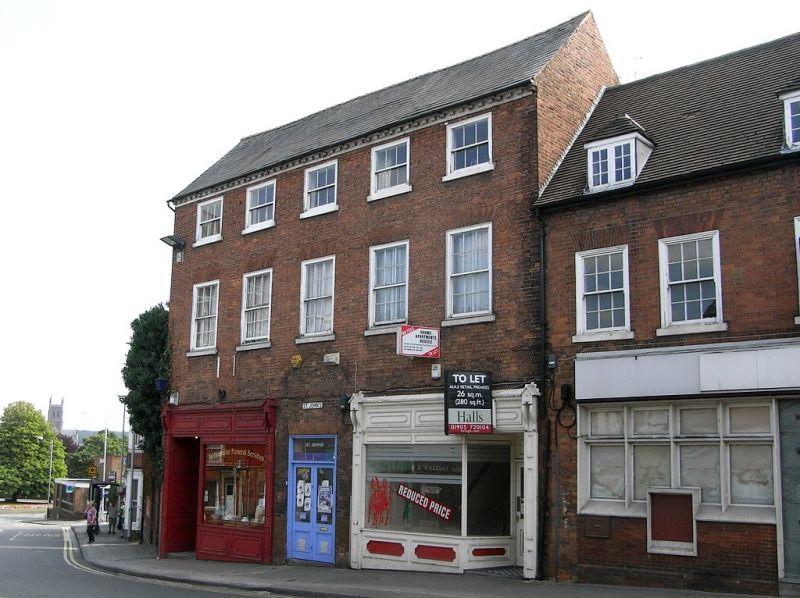
Terraced house, now shop and offices. c1720-40 with later additions and alterations. Red brick with stucco dressings, slate roof; dentilled eaves, painted. Single-depth plan with central entrance hall and rear staircase projection. Service range at right-angles to rear right and C20 range similarly arranged to rear left. 3 storeys. 5 first-floor windows. Upper-floor windows are 3/3, first-floor are 6/6, all near-flush frames under flat gauged-brick arches, painted stucco sills. Ground-floor has 2 early/mid C20 shopfronts (that to left much altered c1991), with individual entrances to left- and right-sides respectively; further central entrance to upper floors, C20 part-glazed doors.
INTERIOR: Very little retained part from some door architraves and a quite fine staircase to first-floor and above with 'barley-sugar' balusters.
HISTORICAL NOTE: Marks on the brickwork over the central entrance show where a pediment has been fixed; this is far above the head of the present door and overlight. It is also possible to see where 4 ground-floor windows, aligned with those above, have been infilled. The interior layout indicates that the ground-floor has been lowered by the removal of a semi-basement. The 1886 OS map shows an external flight of steps accessing the entrance.
External links are from the relevant listing authority and, where applicable, Wikidata. Wikidata IDs may be related buildings as well as this specific building. If you want to add or update a link, you will need to do so by editing the Wikidata entry.


Other nearby listed buildings
