Latitude: 51.3423 / 51°20'32"N
Longitude: 1.4192 / 1°25'9"E
OS Eastings: 638226
OS Northings: 165910
OS Grid: TR382659
Mapcode National: GBR X0D.ZJT
Mapcode Global: VHMCW.KJ4B
Plus Code: 9F338CR9+WM
Entry Name: Prayer hall and section of attached cemetery wall to Ramsgate Jewish Cemetery
Listing Date: 17 March 2008
Grade: II
Source: Historic England
Source ID: 1392476
English Heritage Legacy ID: 502750
ID on this website: 101392476
Location: West Dumpton, Thanet, Kent, CT11
County: Kent
District: Thanet
Civil Parish: Ramsgate
Built-Up Area: Ramsgate
Traditional County: Kent
Lieutenancy Area (Ceremonial County): Kent
Tagged with: Architectural structure
1413/0/10041
DUMPTON PARK ROAD
RAMSGATE
Prayer hall and section of attached cemetery wall to Ramsgate Jewish Cemetery
17-MAR-08
II
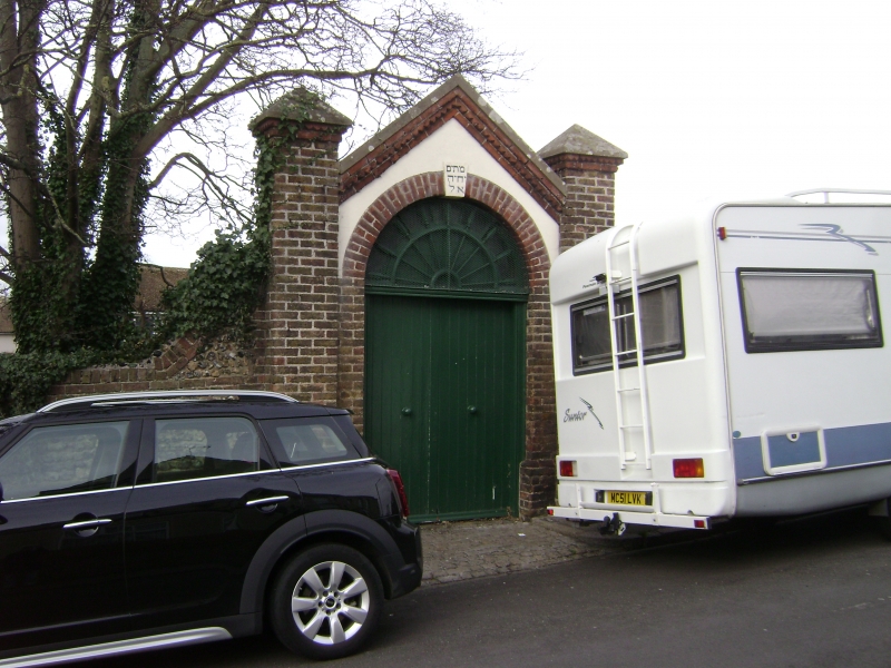
Prayer hall and attached cemetery boundary wall. Circa 1872 prayer hall or 'ohel' built of brick, rendered, with gabled slate roof and attached wall of flint and stock brick.
PLAN: Single-storey rectangular structure with elaborate entrance to the west and attached section of wall to north and south.
EXTERIOR: The west or entrance front has a gable with brick dogtooth cornice flanked by tall square stock brick piers. These have pyramidal cemented caps with red brick dogtooth moulding. Beneath the gable is a round-headed entrance arch with keystone bearing the incised Hebrew date of construction. There is a semi-circular fanlight and plank double door. Attached to the north and south are sections of cemetery boundary walls about 2m high, constructed of flint with stock brick lacing courses, brick piers and plain copings which are ramped up by the side of the ohel. The 1931 extension of the boundary wall is not included in the listing.
INTERIOR: A Hebrew inscription to the interior can be translated as 'The Dead will the Lord make live" from the daily liturgy.
HISTORY: This cemetery was established privately by Benjamin Norden in 1872 in order to bury his wife and was given to the Jewish community of Ramsgate. Although Jews had been resident in Ramsgate since 1786, Sephardic Jews had, up to this time, been buried at Mile End in London and Ashkenazi Jews at Canterbury. A plan dated 9th January 1878 and the 1896 Ordnance Survey map shows that the cemetery was originally a small square plot of ground surrounding the ohel, which was presumably built in 1872 when the cemetery was established. The burial ground has been administered by the Spanish and Portuguese Jewish community since 1887 and was extended in 1931 as shown on the 1939 OS map.
SOURCES:
Sharman Kadish "Jewish Heritage in England - An Architectural Guide". English Heritage (2006) p.63
REASONS FOR DESIGNATION:
* This is an intact ohel of which only about 55 examples are known to exist in England of which only a handful are listed;
* The ohel was built circa 1872; only one listed example and two unlisted are earlier in date;
* It is a rare example of an ohel at a privately-owned cemetery which was then donated to the local Jewish community;
* The attached contemporary part of the cemetery wall is part of the original design.
The prayer hall or ohel to Ramsgate Jewish Cemetery and the contemporary section of attached cemetery wall is designated at Grade II for the following principal reasons:
* It is an intact example of an ohel of which only about 55 examples are known to exist in England and of these only four are currently listed;
* The ohel was built circa 1872 and only one listed and two unlisted examples are earlier in date;
* It is a rare example of an ohel to a private cemetery, donated to the local Jewish community;
* The attached contemporary part of the cemetery wall is part of the original design.
External links are from the relevant listing authority and, where applicable, Wikidata. Wikidata IDs may be related buildings as well as this specific building. If you want to add or update a link, you will need to do so by editing the Wikidata entry.


Other nearby listed buildings