Approximate Location Map
Large Map »
Latitude: 52.4869 / 52°29'12"N
Longitude: -1.9158 / 1°54'56"W
OS Eastings: 405813
OS Northings: 287666
OS Grid: SP058876
Mapcode National: GBR 5W6.WD
Mapcode Global: VH9YW.RR1F
Plus Code: 9C4WF3PM+QM
Entry Name: The Red Lion Public House
Listing Date: 29 April 2004
Grade: II
Source: Historic England
Source ID: 1392832
English Heritage Legacy ID: 505873
ID on this website: 101392832
Location: Brookfields, Birmingham, West Midlands, B18
County: Birmingham
Parish: Non Civil Parish
Built-Up Area: Birmingham
Traditional County: Warwickshire
Lieutenancy Area (Ceremonial County): West Midlands
Church of England Parish: Birmingham St Paul
Church of England Diocese: Birmingham
Tagged with: Pub
BIRMINGHAM
997/0/10293 WARSTONE LANE
29-APR-04 95
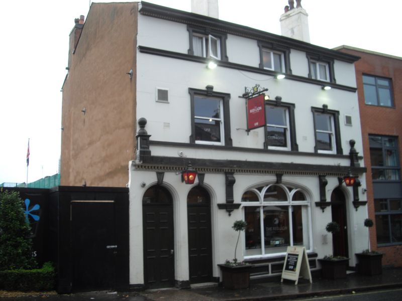
Public House 'The Red Lion'
GV II
Public House. Late C19 with late C20 internal remodelling. Rendered and painted red brick with painted stone dressings, ridge and gable chimneys and a slate roof covering.
PLAN: Irregular L-shaped plan with stepped service range to west.
EXTERIOR: 3 bay, 2 1/2 storey near-symmetrical front with wide 3-light display window to centre, the lights with semi-circular heads within a wide shallow- arched opening. To the left, a pair of semi-circular arch-headed doorways with painted keyblocks, the outer opening an entry to an enclosed passage, the other a former entry to a front bar. To the right, the main entrance to the public house. All doorways have moulded surrounds and overlights. Wide display fascia supported by deep brackets rising from corbels flanking the door and window openings. Fascia cornice with ball finials to ends. 3 upper floor windows with moulded, keyed and shouldered surrounds, and undivided sash frames. Upper floor with moulded and keyed sill band and shallow window surrounds, detailed as below, but now with 2- light C20 casement frames.
INTERIOR: Bar interiors remodelled late C20, but with moulded cornices retained, and geometric patterned encaustic tile work to main entrance passage.
HISTORY: A public house is shown on this site on the 1855 Piggot-Smith map. The present building appears on the 1887 Ordnance Survey map, suggesting a rebuilding or comprehensive remodelling between the 2 dates.
A late C19 public house in the heart of a specialist manufacturing district, now considered to be of international interest. The exterior of the building is detailed in the same manner as many of the small domestic - scale manufactories in the surrounding area, but was quite clearly constructed as a public house.
External links are from the relevant listing authority and, where applicable, Wikidata. Wikidata IDs may be related buildings as well as this specific building. If you want to add or update a link, you will need to do so by editing the Wikidata entry.


Other nearby listed buildings
