Approximate Location Map
Large Map »
Latitude: 53.6 / 53°35'59"N
Longitude: -1.1938 / 1°11'37"W
OS Eastings: 453448
OS Northings: 411793
OS Grid: SE534117
Mapcode National: GBR NV3T.B7
Mapcode Global: WHDCN.MSQ1
Plus Code: 9C5WHRX4+XF
Entry Name: Pinfold
Listing Date: 17 June 2010
Grade: II
Source: Historic England
Source ID: 1393847
English Heritage Legacy ID: 505996
ID on this website: 101393847
Location: Burghwallis, Doncaster, South Yorkshire, DN6
County: Doncaster
Civil Parish: Burghwallis
Built-Up Area: Burghwallis
Traditional County: Yorkshire
Lieutenancy Area (Ceremonial County): South Yorkshire
Church of England Parish: Burghwallis St Helen
Church of England Diocese: Sheffield
Tagged with: Animal pound
BURGHWALLIS
1487/0/10011 WELL LANE
17-JUN-10 Pinfold
II
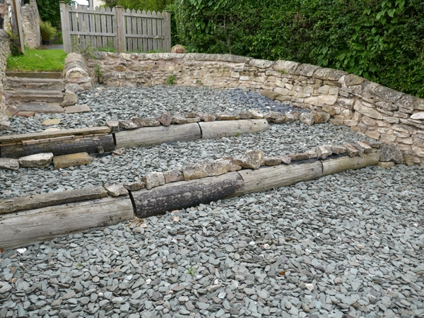
Village pinfold or pound, mid C18 or earlier of limestone construction.
PLAN: Roughly U-shaped formed at the end of a sloping lane leading from the village to the common fields. The south east corner is angled, while the south west is curved and contains an entrance. The east and west walls of the pinfold continue beyond the pinfold's northern boundary wall flanking the lower section of the former lane.
DESCRIPTION: The pinfold is roughly U-shaped in plan and approximately 5.7m wide. The enclosing walls are constructed of roughly-coursed limestone, with curved coping stones. The north wall, which has been strengthened by vertical orthostats and has steps at its west end, stands a few courses high and carries a modern sewerage pipe; on the south side, the walls rise to approximately 1.5m in accordance with the drop in ground level. The entrance, with a modern gate, is situated in the south west corner. There is a small stone-lined watering trough in the centre of the pinfold fed by a natural spring, and a later low stone built platform against the west wall.
HISTORY: Documentary evidence for the presence of a pinfold at Burghwallis can be traced through the Anne family Squire record to 1753. Here the Manor Court Book states that the pinder for the period 1753 -1758 was Thomas Mallinson. He was succeeded by his wife, Dorothy, who remained in post for the next 17 years. Records from the 1780 Burghwallis Manor Court Jury provide evidence for the holding of sheep, pigs and horses or beasts. It is considered that these records refer to the present structure located adjacent to former common grazing land and a quarry, the most likely source of its building materials. The form of existing field boundaries on the 1813 Enclosure Award map are thought to indicate the location of the pinfold at the south end of an access route from the village to the common fields beyond. It is not depicted on subsequent Ordnance Survey editions presumably as it had gone out of use at enclosure.
SOURCES:
Margaret L.P. Burns `Burghwallis and Bentley: A Comparative Study of the Development of two South Yorkshire Parishes' http://burghwallis.com/pdf/Burghwallis%20%20&%20Bentley%20Full%20&%20Maps.pdf (Accessed 20-Apr-2009)
B.M. Willmott Dobbie, `Pounds or Pinfolds, and Lockups: Beast and Man in Custody' (Bath, 1979)
Edwin Pretty, Pinfolds in the Doncaster Borough `Yesterday Today: Doncaster's Local History Review' (Issue no.40 - April 2003)
REASONS FOR DESIGNATION:
The pinfold at Burghwallis is designated at Grade II for the following principal reasons:
* It is a well-preserved example of an increasingly rare building type
* For its historic interest as a surviving component of medieval open field stock management
* It is an effectively intact pre-1840 structure
* It compares favourably with other listed examples locally, with the added interest of a drinking trough.
The pinfold at Burghwallis is recommended for designation at Grade II for the following principal reasons:
* It is a well-preserved example of an increasingly rare building type
* For its historic interest as a surviving component of medieval open field stock management
* It is an effectively intact pre-1840 structure
* It compares favourably with other listed examples locally, with the added interest of a drinking trough.
External links are from the relevant listing authority and, where applicable, Wikidata. Wikidata IDs may be related buildings as well as this specific building. If you want to add or update a link, you will need to do so by editing the Wikidata entry.


Other nearby listed buildings
