Approximate Location Map
Large Map »
Latitude: 51.3836 / 51°23'0"N
Longitude: -2.3602 / 2°21'36"W
OS Eastings: 375030
OS Northings: 165007
OS Grid: ST750650
Mapcode National: GBR 0QH.B39
Mapcode Global: VH96M.1HM6
Plus Code: 9C3V9JMQ+CW
Entry Name: The Oliver Public House
Listing Date: 11 August 1972
Last Amended: 15 October 2010
Grade: II
Source: Historic England
Source ID: 1394959
English Heritage Legacy ID: 510377
ID on this website: 101394959
Location: Bath, Bath and North East Somerset, Somerset, BA1
County: Bath and North East Somerset
Parish: Non Civil Parish
Built-Up Area: Bath
Traditional County: Somerset
Lieutenancy Area (Ceremonial County): Somerset
Church of England Parish: Bath St Michael Without
Church of England Diocese: Bath and Wells
Tagged with: Pub
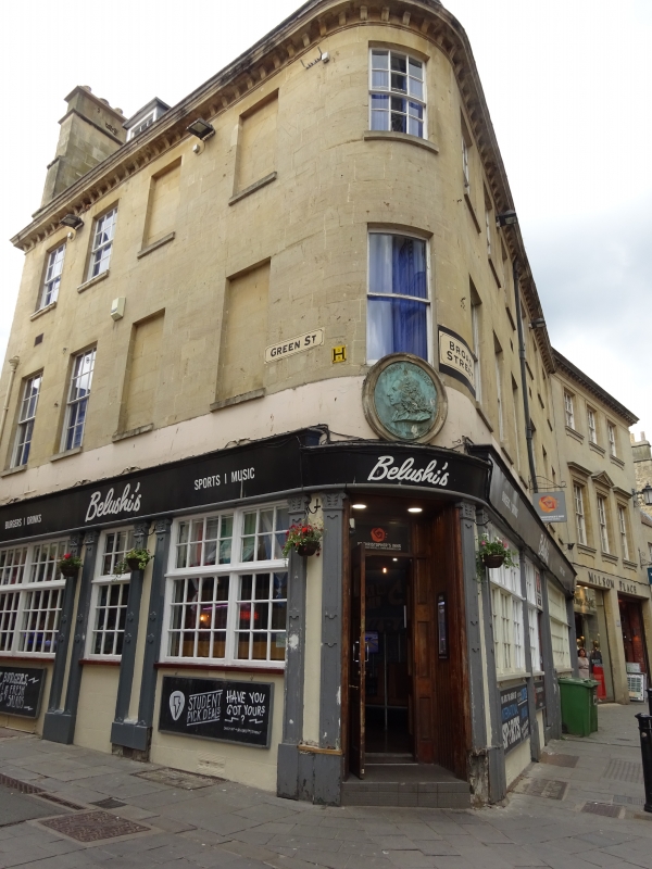
BROAD STREET
(West side)
No.1 The Oliver Public House
(Formerly Listed as:
GREEN STREET (North side)
No.9 Oliver Inn)
11/08/72
GV II
Two houses, now public house with accommodation over. Late C18, but very restored in mid C20.
MATERIALS: Limestone ashlar with Welsh slate roofs. Square block with double depth former house facing Green Street (No.1) and house with odd planning backing onto end of terrace with fronts to Broad Street and to Green Street (No.9), now amalgamated into one public house and restaurant.
EXTERIOR: Three storeys and attics. Six windows to Broad Street, one to corner, four to Green Street of which two right hand ones are blind recesses. All windows are plain sashes facing Broad Street except for left hand three on top floor, corner has six/six above plain, six/six sashes to Green Street. Ground floor wholly mid/late C20 public house front of `Georgian character' with multi-paned lights divided by pilasters, some of which are paired. Cornice, parapet, mansard roof now very much mid/late C20 in character with four dormers to Broad Street and one to Green street, all flat topped with six/six sashes and slated cheeks. Three ashlar stacks with almost all pots gone. Rear elevation ashlar to No.1 and part rubble to No.9. Slate mansard roof with two old six/six dormers to No.1 and small four/four one to No.9.
INTERIOR: Much altered on ground floor.
Listing NGR: ST7503065007
External links are from the relevant listing authority and, where applicable, Wikidata. Wikidata IDs may be related buildings as well as this specific building. If you want to add or update a link, you will need to do so by editing the Wikidata entry.


Other nearby listed buildings
