Latitude: 54.1344 / 54°8'4"N
Longitude: -0.8008 / 0°48'3"W
OS Eastings: 478448
OS Northings: 471620
OS Grid: SE784716
Mapcode National: GBR QNVM.FN
Mapcode Global: WHFBG.NBVT
Plus Code: 9C6X45MX+QM
Entry Name: Buildings in Talbot Yard
Listing Date: 27 October 2010
Grade: II
Source: Historic England
Source ID: 1395159
English Heritage Legacy ID: 508036
ID on this website: 101395159
Location: Malton, North Yorkshire, YO17
County: North Yorkshire
District: Ryedale
Civil Parish: Malton
Built-Up Area: Malton
Traditional County: Yorkshire
Lieutenancy Area (Ceremonial County): North Yorkshire
Church of England Parish: New Malton St Michael
Church of England Diocese: York
Tagged with: Building
MALTON
801/0/10003 YORKERSGATE
27-OCT-10 BUILDINGS IN TALBOT YARD
GV II
Carriage house, with associated buildings, early C19 for the Wentworth family and the Talbot Hotel.
MATERIALS
Mainly red brick with limestone dressings and pantiled roofs.
PLAN
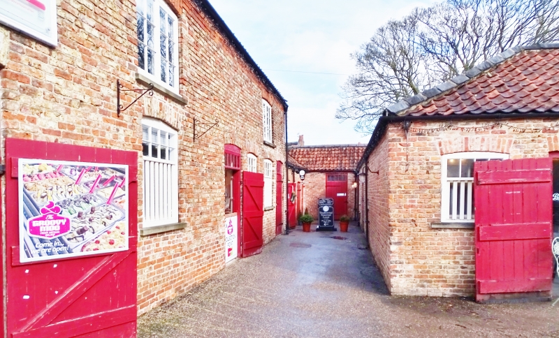
Talbot Yard consists of a pair of yards, both open to the south, divided by a two-storey north-south stable range. The yards are separated from the road by the Grade II listed wall attached to No. 50, Yorkersgate. The main, eastern, yard has a carriage house on its eastern side with a single-storey saddle room to its north. Beyond to the north, extending eastwards, there is a cobbled passage flanked by looseboxes. On the north side of the eastern yard there is a two-storey east-west range that has a through-passage exiting Talbot Yard northwards. The smaller western yard is bound to the west by the Mount Hotel (which is not included in this designation). On the north side is a two-storey stone building with a lean-to gig house.
CARRIAGE HOUSE
Central, two-and-a-half storey, gabled bay, flanked by two-bay, one-and-a-half storey wings that are slightly set back. The central section has a carriage entrance with a timber lintel with a brick relieving arch above. To the first floor there is a pair of domestic window openings. Above is an equilateral arched opening to the attic interpreted as being for a dovecot. The gable is raised and coped with decayed kneelers. The flanking wings form ground floor stabling with domestic accommodation above (for grooms) that interconnects with the first floor of the central section. Access to the first floor is via an added external staircase to the left of the central section. The gable end of the south wing is coped, retaining kneelers and has two ground-floor windows with one at the first floor. The rear (east) elevation is blind and retains fragments of earlier stone walling suggested to be remains of a C17 boundary wall.
Interior: Lime plastered throughout. Stables retain stall divisions, hay racks and other fixtures and fittings. Fireplace position on the first floor of the central section.
THROUGH PASSAGE BUILDING
This is of two storeys and six bays with three ground-floor doorways on the south side, that to the west opening onto a through-passage which exits Talbot Yard northwards. The first floor has two taking-in doors (presumably to a hay loft) which are boarded. Brickwork suggests that the roof has been raised. The ground floor retains stall partitions and other stabling fixtures and fittings.
SINGLE STOREY RANGES
These flank the cobbled passageway that extends eastwards from the eastern yard and mainly consist of looseboxes generally retaining features such as hay racks. Breaks in brickwork indicate that the buildings are of different builds. A plan of 1920 marks the eastern end of the south range as a granary and the western end as a saddle room. The saddle room faces west and retains a fireplace opening, as well as timber planking with pegs to some of its walls. At the time of the inspection, the roof of the central section of the southern range had largely collapsed, although the timber partitions forming the looseboxes survived.
NORTH-SOUTH RANGE
This is of two storeys and has a brick-built east wall, a dressed stone west wall and a rubble stone south gable that is coped, retaining kneelers. The east elevation is of most interest, retaining door and window openings for stalled stables, with hayloft openings above. These generally retain joinery, although at the time of the inspection the openings were blocked internally with blockwork. At the north end there is a larger blocked opening (formerly internal) to an open-fronted shed forming a cross wing connecting to the through-passage building (q.v.). At the time of the inspection, only the eastern part of this open-fronted shed remained roofed. The south gable of the north-south range has an inserted vehicle entrance. On the west side there is a brick and timber boarded lean-to extension which is considered to be an early C20 alteration that is not of special interest. This elevation was probably originally blind. The north-south range is altered internally.
GIG HOUSE RANGE
The north side of the western yard is formed by a dressed stone, two-storey building with a wide, inserted roof dormer which is probably an early C20 alteration. To the west end of the south elevation there is a basket arched carriage entrance that has been infilled with brickwork. To the centre there is a timber linteled garage entrance with a hayloft opening above that is partially obscured by a lean-to roof. This roof is supported by a pair of cast iron pillars that are embossed "T.READ MALTON 1871".
HISTORY
Talbot Yard developed to provide stabling and carriage housing for the Talbot Hotel, across the road to the south. The Talbot Hotel (listed Grade II*) was owned by the Wentworth family from the mid-C18 and became Malton's first private hotel, becoming a focal point for members of the town's horse-breeding and racing community. The hotel was later used as a coaching inn by "The Mail" operating between York and Scarborough during the C19.
Although the stone-built range on the north side of the western yard (with the basket arched carriage entrance) may be marked on an 1801 Terrier Map, the first of the current buildings to be clearly depicted is the carriage house which is not shown on the 1801 Terrier Map, but is shown by 1809. Also shown is a range extending eastwards from the carriage house's northern end which could be the single-storey range on the south side of the cobbled passage, although changes in brickwork suggests that this range is later in date than the carriage house. Talbot Yard's complex of buildings (apart from lean-to sheds) appeared to be effectively complete by an 1843 terrier map. By the 1892 Ordnance Survey map there had been some limited demolition to the south of the central range between the two yards (possibly explaining its rubble-built south gable). In the western yard, open-fronted sheds had been added of which one range still survives with cast iron pillars dated 1871. A plan of Talbot Yard in 1920 indicates the contemporary functions of the buildings, showing them mainly as looseboxes and stalled stables.
REASON FOR DESIGNATION DECISION
The buildings of Talbot Yard, a carriage house, stabling and other associated buildings mainly dating to the early C19 and built to serve a hotel, are designated at Grade II for the following principal reasons:
* Date: the carriage house predates 1809 and the rest of the complex was mainly constructed by 1843
* Group value: the carriage house has visual group value with the Grade II* listed Talbot Hotel and the Grade II listed boundary wall and pedestrian archway, with the complex as a whole having strong functional group value with the hotel
* Historic interest: the ample provision for stabling for the hotel is considered to reflect the importance of Malton and Norton in horse breeding and racing in the C19
* Stable fittings: the survival of C19 stable fittings such as stalls, hay racks and feed troughs is of note.
Yes List
External links are from the relevant listing authority and, where applicable, Wikidata. Wikidata IDs may be related buildings as well as this specific building. If you want to add or update a link, you will need to do so by editing the Wikidata entry.


Other nearby listed buildings