Approximate Location Map
Large Map »
Latitude: 51.3834 / 51°23'0"N
Longitude: -2.3608 / 2°21'38"W
OS Eastings: 374985
OS Northings: 164993
OS Grid: ST749649
Mapcode National: GBR 0QH.9XL
Mapcode Global: VH96M.1H89
Plus Code: 9C3V9JMQ+9M
Entry Name: 3 and 3A, Green Street
Listing Date: 12 June 1950
Last Amended: 15 October 2010
Grade: II
Source: Historic England
Source ID: 1396282
English Heritage Legacy ID: 511686
ID on this website: 101396282
Location: Bath, Bath and North East Somerset, Somerset, BA1
County: Bath and North East Somerset
Parish: Non Civil Parish
Built-Up Area: Bath
Traditional County: Somerset
Lieutenancy Area (Ceremonial County): Somerset
Church of England Parish: Bath St Michael Without
Church of England Diocese: Bath and Wells
Tagged with: Building
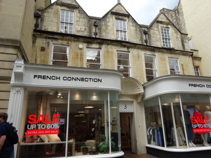
GREEN STREET
(North side)
Nos.3 AND 3A
12/06/50
GV II
House in row, with shops. c1716 with C19 and C20 alterations and additions.
MATERIALS: Dressed squared stone, concrete tile roof.
PLAN: House set back from street, and fronted by early C20 display fronts which cover most of ground floor apart from doorway, small set back bay to right entry to No.3A.
EXTERIOR: Three storeys, windows all deep sashes in bolection mould architraves, top floor has three face gables, each with original eighteen-pane, and with floating cornice hoods, and first floor has five close spaced plain sashes, under full width worn moulded cornice. Ground floor C20 glass door in bolection mould architrave and painted-in transom light under very fine shell hood on brackets and pulvinated frieze, flanking display fronts have quadrant glazing and pilasters, later than Green's photograph of early C20. Lead downpipes and hopperheads between gables which, like ends, have saddleback copings. Rebuilt ashlar stack at each end.
INTERIOR: Not inspected; now in retail use they appear to have undergone considerable alteration. Inspected by Bath Council in 1989, most of the stone fireplaces intact with some Regency fireplaces.
HISTORY: The street was laid out in 1715 on the site of a bowling green, to a very narrow width; this building is an important early survivor, one of earliest C18 houses in Bath, still using the Cotswold vernacular format with gables to street. Green (op cit) has a reconstruction drawing of the facade (page 20).
SOURCES: (Ison W: The Georgian Buildings of Bath: London: 1948-: 118; Green M: The Eighteenth Century Architecture of Bath: Bath: 1904-: 20; PL IX; The Bath Chronicle: Images of Bath: Derby: 1994-: 34; Finch G: Shopfront Record, Bath City Council: 1992-).
Listing NGR: ST7498564993
External links are from the relevant listing authority and, where applicable, Wikidata. Wikidata IDs may be related buildings as well as this specific building. If you want to add or update a link, you will need to do so by editing the Wikidata entry.


Other nearby listed buildings
