Latitude: 51.5024 / 51°30'8"N
Longitude: -0.1623 / 0°9'44"W
OS Eastings: 527650
OS Northings: 179759
OS Grid: TQ276797
Mapcode National: GBR 7H.RM
Mapcode Global: VHGQZ.4HKN
Plus Code: 9C3XGR2Q+W3
Entry Name: The Pan Statue
Listing Date: 19 January 2016
Grade: II
Source: Historic England
Source ID: 1431163
Also known as: The Rush of Green
Bowater House Group
The Bowater House Group
Bowater group
Pan Group
Pan Statue
The Return of Spring
The Family
ID on this website: 101431163
Location: Hyde Park Corner, Westminster, London, SW1X
County: London
District: City of Westminster
Electoral Ward/Division: Knightsbridge and Belgravia
Parish: Non Civil Parish
Built-Up Area: City of Westminster
Traditional County: Middlesex
Lieutenancy Area (Ceremonial County): Greater London
Church of England Parish: Holy Trinity South Kensington
Church of England Diocese: London
Tagged with: Sculpture
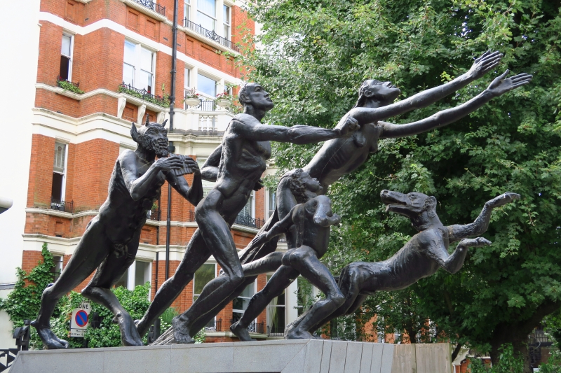
Sculptural group, by Sir Jacob Epstein for the Land Securities Investment Trust, sculpted in 1957-9 and erected in 1961.
Sculpture, by Sir Jacob Epstein for the Land Securities Investment Trust, 1957-9, erected 1961.
MATERIALS: bronze. The replacement plinth* of circa 2010 is of granite and slate, and is not of special interest.
DESCRIPTION: the sculpture, a group of five running figures, is approximately 285cm in length, occupying a long and narrow space within the central reservation of the Edinburgh Gate. The elongated nude forms of a man, woman and boy, preceded by their dog, are shown rushing northwards, creating a dramatic diagonal composition in their leaping onward movement towards the Park. At their heels Pan drives them forward with his pipes. The piece has been described as '‘a sort of symbolic Bacchic rout from the city into the country'’ (Jacob Epstein: Sculpture and Drawings, Whitechapel Art Gallery, 1987).
The current plinth is intended to reflect the diagonal upward movement of the figures: the ends of the plinth slope forwards, the rear slope being more pronounced. A skin of pale grey granite covers the front, back and top of the plinth, creating an outline when viewed from the side.
*Pursuant to s.1 (5A) of the Planning (Listed Buildings and Conservation Areas) Act of 1990 ('the Act') it is declared that the aforementioned feature is not of special architectural or historical interest.
The period after 1945 saw a shift from commemorative sculpture and architectural enrichment to the idea of public sculpture as a primarily aesthetic contribution to the public realm. Sculpture was commissioned for new housing, schools, universities and civic set pieces, with the counties of Hertfordshire, London and Leicestershire leading the way in public patronage. Thus public sculpture could be an emblem of civic renewal and social progress. By the late C20 however, patronage was more diverse and included corporate commissions and Arts Council-funded community art. The ideology of enhancing the public realm through art continued, but with divergent means and motivation.
Visual languages ranged from the abstraction of Victor Pasmore and Phillip King to the figurative approach of Elisabeth Frink and Peter Laszlo Peri, via those such as Lynn Chadwick and Barbara Hepworth who bridged the abstract/representational divide. The post-war decades are characterised by the exploitation of new – often industrial – materials and techniques including new welding and casting techniques, plastics and concrete , while kinetic sculpture and ‘ready mades’ (using found objects) demonstrate an interest in composite forms.
Sir Jacob Epstein (1880-1959) was born in New York, to Polish-Jewish parents. Attending art classes at the Art Student’s League, Epstein began by concentrating on drawing, but turned to sculpture circa 1899-90, after working as an ice-cutter in New Jersey. He got a job in a bronze foundry, whilst studying sculpture under George Grey Barnard; on the proceeds of illustrating Hutchins Hapgood’s ‘The Spirit of the Ghetto’ (1902) – about the Lower East Side, where Epstein had grown up – he was able to go to Paris, where he attended the École des Beaux-Arts and the Académie Julian, as well as studying pre-classical and primitive sculpture in museums. He settled in London in 1905, becoming a British subject in 1907.
Throughout his career Epstein’s work provoked controversy. Of the response to his eighteen nude figures sculpted for Charles Holden’s British Medical Association building on the Strand (now Zimbabwe House, listed Grade II*), which was unveiled in 1908, and the sculptures later mutilated, Epstein concluded that at least ‘London had become sculpture-conscious’. Other notable examples include 'Rima' (1924-5, listed at Grade II) placed in Hyde Park as a memorial to the naturalist and author W H Hudson, and 'Night and Day' (1928-9) for Holden’s London Underground headquarters in St James’s Park (the building is listed at Grade I). Epstein’s portrait sculptures were more generally well-regarded, and he received commissions to make portraits of many eminent figures. During the 1930s Epstein produced a number of monumental carved sculptures on symbolic themes, including 'Jacob and the Angel' (1940-1, now in the Tate collection), which appeared to be at odds with the prevailing style of more abstract modernism. After the Second World War Epstein’s public recognition increased; his lead 'Madonna and Child' for the Convent of the Holy Child Jesus, Cavendish Square, London (1950-2, the bridge on which the sculpture is place is listed at Grade II*) received unprecedented public and critical acclaim.
In 1913 Epstein was a founding member of the London Group – an association of radical English artists to provide an alternative to the Royal Academy for exhibiting new work - and in the same year had his first show at the Twenty One Gallery, Adelphi, London; thereafter he exhibited mainly at the Leicester Galleries. The Arts Council honoured him with a retrospective exhibition at the Tate Gallery in 1953. He was knighted in 1954 and died in London on 19 August 1959.
This sculpture was commissioned in November 1957 by Sir Harold Samuel, chairman of the Land Securities Investment Trust, to complement Bowater House, the office block by Guy Morgan and Partners which was at that time being constructed on the south side of Hyde Park; the sculpture was a gift from Land Securities to the nation. The sculpture was purposely designed by Epstein for its position on the central reservation at Edinburgh Gate, which passed through the centre of Bowater House, though the Royal Fine Arts Commission doubted that it would be seen to advantage there. Epstein made the finishing touches to the plaster model on the night he died in August 1959, at home in Hyde Park Gate. The bronze was cast at the Morris Singer Foundry and erected at Edinburgh Gate in April 1961. The piece has been known variously as 'The Return of Spring', 'The Family', 'The Rush of Green', and the 'Pan Group/Pan Statue', as well as the 'Bowater House Group'. Responses to the work have been mixed: the Buildings of England describes it as ‘'An embarrassing decline from his works of a few years before'’ and Ian Nairn, who saw it as a ''sad end'' to Epstein's career, was put in mind of ''an incestuous family fleeing into Hyde Park from the Vice Squad''; on the other hand, Richard Cork observes ''the almost reckless sense of energy that Epstein may have guessed would be his last'', and his biographer, Stephen Gardiner, says that it represents ''Epstein at his happiest''.
With the demolition of Bowater House in 2006, and its replacement by Richard Rogers’s residential development, One Hyde Park, the Edinburgh Gate was re-routed, and now runs between One Hyde Park to the east, and the late-C19 mansion block, Wellington Court, on its other side. The sculpture was repositioned, on a new plinth, in the central reservation of the re-routed Edinburgh Gate, in 2010.
The sculptural group now known as the Pan Statue, by Sir Jacob Epstein, sculpted in 1957-9 and erected in 1961, is listed at Grade II for the following principal reasons:
* Artistic interest: a compelling response to its setting at an entrance to Hyde Park, the sculpture demonstrates the energy and spirit associated with its creator in an expressive and dynamic form;
* Historic interest: as the final work by the internationally renowned artist Sir Jacob Epstein, commissioned by a commercial developer as a gift to the nation.
External links are from the relevant listing authority and, where applicable, Wikidata. Wikidata IDs may be related buildings as well as this specific building. If you want to add or update a link, you will need to do so by editing the Wikidata entry.


Other nearby listed buildings