Approximate Location Map
Large Map »
Latitude: 56.4861 / 56°29'10"N
Longitude: -3.1291 / 3°7'44"W
OS Eastings: 330566
OS Northings: 733242
OS Grid: NO305332
Mapcode National: GBR VF.Y92W
Mapcode Global: WH6Q3.X74H
Plus Code: 9C8RFVPC+F9
Entry Name: Balruddery Road Bridge
Listing Name: Balruddery, Balruddery Farm, Road Bridge over Blacklaw Burn, North of Balruddery Farm
Listing Date: 25 February 1993
Category: C
Source: Historic Scotland
Source ID: 343366
Historic Scotland Designation Reference: LB10859
Building Class: Cultural
ID on this website: 200343366
Location: Liff and Benvie
County: Angus
Electoral Ward: Monifieth and Sidlaw
Parish: Liff And Benvie
Traditional County: Perthshire
Tagged with: Road bridge
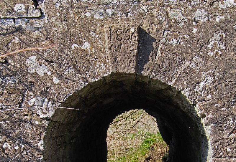
Dated 1856. Single-span, round-headed arch road bridge over burn. Grey rubble sandstone, some red sandstone to N arch, rounded rubble coping. Dated at S keystone.
External links are from the relevant listing authority and, where applicable, Wikidata. Wikidata IDs may be related buildings as well as this specific building. If you want to add or update a link, you will need to do so by editing the Wikidata entry.


Other nearby listed buildings
