Approximate Location Map
Large Map »
Latitude: 55.6044 / 55°36'15"N
Longitude: -2.6779 / 2°40'40"W
OS Eastings: 357385
OS Northings: 634743
OS Grid: NT573347
Mapcode National: GBR 93RM.1S
Mapcode Global: WH7WQ.TDZF
Plus Code: 9C7VJ83C+QR
Entry Name: Leaderfoot Viaduct
Listing Name: Leaderfoot Viaduct
Listing Date: 16 March 1971
Category: A
Source: Historic Scotland
Source ID: 348670
Historic Scotland Designation Reference: LB15145
Building Class: Cultural
Also known as: Drygrange Viaduct
ID on this website: 200348670
Location: Melrose
County: Scottish Borders
Electoral Ward: Leaderdale and Melrose
Parish: Melrose
Traditional County: Roxburghshire
Tagged with: Railway bridge Viaduct Railway viaduct
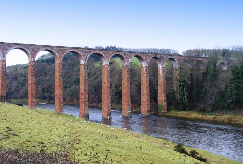
Charles Jopp and Wylie & Peddie (engineers), 1865. Outstanding former railway viaduct spanning the River Tweed on 19 tall, slender arches at a height of 126ft. Red sandstone piers, walls and abutments. Brickwork arches, each of 43ft span.
An exceptional 19th century railway viaduct, built for the Berwickshire Railway branch line and formerly connecting the 'Waverley Route' running between Edinburgh and Hawick, to Duns and Reston. Prominently located, its towering height and slender proportions make a very positive contribution to its setting. The viaduct is intervisible with 'Drygrange Old Bridge' built 1780 (see separate listing), adding to its wider contextual interest and value.
Aberdeen born civil engineer Charles Jopp became Chief Engineer to the North British Railway Company in 1850 and was in charge of much of the construction of the original North British Railway network and the Forth and Clyde Junction Railways.
The line was severed by flooding in 1948 but the Leaderfoot Viaduct remained operational in some capacity until 1965. Some tiers and strengthening buttresses were added to the abutments and S pier end, 1992-95.
Upgraded from Category B to A (1986). List description updated at resurvey (2010).
External links are from the relevant listing authority and, where applicable, Wikidata. Wikidata IDs may be related buildings as well as this specific building. If you want to add or update a link, you will need to do so by editing the Wikidata entry.


Other nearby listed buildings
