Latitude: 55.605 / 55°36'17"N
Longitude: -2.7501 / 2°45'0"W
OS Eastings: 352838
OS Northings: 634853
OS Grid: NT528348
Mapcode National: GBR 937M.DL
Mapcode Global: WH7WP.QCMZ
Plus Code: 9C7VJ63X+XX
Entry Name: Melrose Bridge
Listing Name: Melrose Bridge
Listing Date: 16 March 1971
Category: B
Source: Historic Scotland
Source ID: 354125
Historic Scotland Designation Reference: LB19719
Building Class: Cultural
Also known as: Darnlee Bridge
Lowood Bridge
Bottle Bridge
ID on this website: 200354125
Location: Melrose
County: Scottish Borders
Electoral Ward: Leaderdale and Melrose
Parish: Melrose
Traditional County: Roxburghshire
Tagged with: Bridge
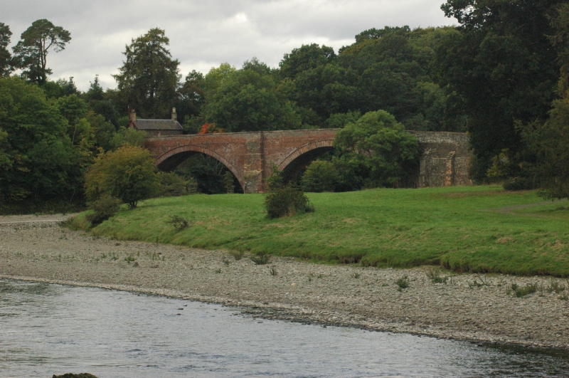
From 1754-1762 (see Notes). Single-carriageway, hump-backed bridge of two 80ft arches with central v-splayed cutwater spanning the Tweed. Squared and snecked, red sandstone rubble with dressed sandstone voussiors and buttressed approaches. Coped parapet with square, recessed pedestrian refuges.
Part of a B-Group comprising Melrose Bridge and Gattonside Toll.
A substantial 18th century road bridge of red sandstone occupying a prominent position in rolling landscape, spanning the Tweed on the sweeping approach road from Galashiels to Melrose. The bridge is flanked by the mid 19th century 'Gattonside Toll' (see separate listing) located at the southerly approach, and Lowood Lodge to the northerly approach, adding wider contextual interest.
The exact building date is not currently known, although it may may have been completed as early as 1762, possibly replacing a failed earlier bridge, subscription for which appears to have been underway in 1754 (see References). This specific river crossing was particularly significant at a period when turnpikes were being constructed in Scotland, with the only other carriage bridge to cross the Tweed at this time located at Kelso. The bridge is also known as 'Darnlee' or 'Lowood', and more locally as the 'Bottle' bridge, probably because broken bottle glass was used an an aggregate in the foundations. Vehicular passage over the single lane carriage way is now controlled by traffic lights.
List description updated at resurvey (2010).
External links are from the relevant listing authority and, where applicable, Wikidata. Wikidata IDs may be related buildings as well as this specific building. If you want to add or update a link, you will need to do so by editing the Wikidata entry.


Other nearby listed buildings