Approximate Location Map
Large Map »
Latitude: 56.6214 / 56°37'17"N
Longitude: -3.8736 / 3°52'24"W
OS Eastings: 285134
OS Northings: 749298
OS Grid: NN851492
Mapcode National: GBR JCT6.SF8
Mapcode Global: WH4LQ.GTNT
Plus Code: 9C8RJ4CG+HH
Entry Name: Tay Bridge, River Tay, Aberfeldy
Listing Name: Tay Bridge
Listing Date: 5 October 1971
Category: A
Source: Historic Scotland
Source ID: 356063
Historic Scotland Designation Reference: LB20861
Building Class: Cultural
Also known as: General Wade's Bridge
Aberfeldy, River Tay, Tay Bridge
Tay Bridge
ID on this website: 200356063
Location: Aberfeldy
County: Perth and Kinross
Town: Aberfeldy
Electoral Ward: Highland
Traditional County: Perthshire
Tagged with: Road bridge Stone arch bridge
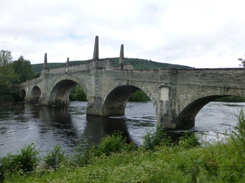
Southwest (upstream) elevation: broad (60' span), taller centre arch with stepped keystone surmounted by white marble panel bearing crown, sceptre and sword at parapet; flanking cutwaters giving way to quoined refuges each containing panelled obelisk base at road level. Flanking arches (35' span) with raised and stepped voussoirs and full-height canted-out refuges with aediculed marble panels giving way to similarly-detailed outer arches (30' span) with small stone cannon projecting at outer elevations to west. Splayed approaches with flat-coped parapets and pyramidal copes.
Northeast (downstream) elevation: mirrors above but aediculed panels with grey stone tablets.
Listed building partly in Weem Parish (west approach and 2 1/2 arches) and Dull Parish (east approach and 2 1/2 arches); East approach only is within the burgh. Erected for The Board of Ordnance to the order of Lt Gen George Wade, the stone was quarried, cut and tooled at local Bolfracks. The 'House of Commons Journal' of 1734 records that "the starlings are of oak, and the piers and landbreasts founded on piles shod with iron". Originally with steeply humpbacked centre and parapets 6' above the roadway. In 1932, two tablets with copies of Wade's original inscriptions were let into the stonework of two obelisk plinths, that to northeast in English and that to southwest in Latin. These record that the bridge, begun in April 1733, was finished within nine months, but this is not strictly true as General Wade stopped work for the winter leaving the bridge without parapets over the side arches. These were added the following year. Mackay records some extra details evident in the 1950s, these include small stone cannon over the small arches each projecting some 2', and hanging iron rings flanking the cutwaters of both centre piers.
Listed building description updated in 2024.
External links are from the relevant listing authority and, where applicable, Wikidata. Wikidata IDs may be related buildings as well as this specific building. If you want to add or update a link, you will need to do so by editing the Wikidata entry.


Other nearby listed buildings
