Approximate Location Map
Large Map »
Latitude: 55.8825 / 55°52'56"N
Longitude: -3.1134 / 3°6'48"W
OS Eastings: 330447
OS Northings: 666043
OS Grid: NT304660
Mapcode National: GBR 60PF.R4
Mapcode Global: WH6T1.4DPR
Plus Code: 9C7RVVJP+XJ
Entry Name: Lasswade Parish Church, Polton Road, Lasswade
Listing Name: Bonnyrigg, Polton Road, Strathesk Church of Scotland (Lasswade Parish Church) Including Boundary Walls and Railings
Listing Date: 16 September 1979
Category: B
Source: Historic Scotland
Source ID: 357965
Historic Scotland Designation Reference: LB22405
Building Class: Cultural
Also known as: Lasswade, Polton Road, Lasswade Parish Church
ID on this website: 200357965
Location: Bonnyrigg and Lasswade
County: Midlothian
Town: Bonnyrigg And Lasswade
Electoral Ward: Bonnyrigg
Traditional County: Midlothian
Tagged with: Church building
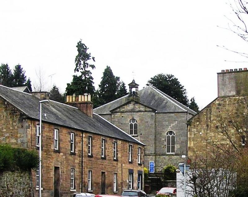
Dated 1830 with porch, bell and some internal features, added by Hardy and Wight, in 1894. 3-bay rectangular-plan, galleried hall church with lower, vestry wing clasping SE angle, on ground rising to SW. Stugged ashlar sandstone to principal and NW elevations; coursed sandstone rubble to rear and SE elevations. Base course to principal elevation, continuous as band course to NW elevation; cill course with datestone to centre; eaves course; raised cills to windows; corniced pediment; quoins to angles; dressed stone belfry and weather vane.
NE (PRINCIPAL) ELEVATION: slightly advanced, pedimented bay to centre: advanced, square-plan porch with cornice and blocking course at ground; window at ground; timber panelled door in each return; window at 1st floor above. Window to each flanking bay.
SW (REAR) ELEVATION: 2-bay with lower wing clasping angle to right. Tall window to each bay with full-height, rendered stack to outer right. Window at ground to wing with non-aligned, stack above.
NW (ROAD) ELEVATION: 2-storey, 2-bay. Window at each floor in each bay.
SE ELEVATION: 2-storey, 2-bay. Window at each floor in bay to right. Single storey wing clasping angle to outer left; boarded door and window in right return; window to left return; window at 1st floor above.
INTERIOR: timber panelled entrance porch with part-glazed internal door with fanlight above; rectangular-plan entrance hall with stone stairs at either end for access to gallery above; curved gallery round three sides of hall church supported by iron shafts denoting aisles at each side; clap-boarding to dado rail height; pulpit to centre of SW wall with access via steps to either side; two round arched stained glass windows, by Ballantine and Gardiner, flanking; organ pipes to left of altar in gallery; portable font; timber slatted pews.
Round-arched, bipartite, stained glass windows with circular central pane above to principal and rear elevations; segmental-arched windows to side elevations; 12-pane timber sash and case windows to wing; piended grey slate roof; flat roof to porch; full-height ashlar coped, rendered brick stack to SW; ashlar coped brick wallhead stack to SW of wing; cast-iron rainwater goods.
BOUNDARY WALLS, GATES AND RAILINGS: stugged and snecked ashlar sandstone with rounded cope; wrought iron, gates and railings with arched gateway.
In ecclesiastical use. Originally built for United Secessionist Church. Became UP 1894; UF 1900; C of S 1929; now serves as the parish kirk in place of former Kirk (built 1793; demolished 1956). In 1894 the church underwent a major overhaul. The entrance porch was added (as a memorial to the Reverend John Robson) along with the bell, the pulpit and its two flanking stained glass windows. The lectern was donated in 1930 as a memorial to the Reverend R H Pryde.
External links are from the relevant listing authority and, where applicable, Wikidata. Wikidata IDs may be related buildings as well as this specific building. If you want to add or update a link, you will need to do so by editing the Wikidata entry.


Other nearby listed buildings
