Approximate Location Map
Large Map »
Latitude: 55.9896 / 55°59'22"N
Longitude: -3.3938 / 3°23'37"W
OS Eastings: 313147
OS Northings: 678275
OS Grid: NT131782
Mapcode National: GBR 20.VRHR
Mapcode Global: WH6S9.VQ26
Plus Code: 9C7RXJQ4+RF
Entry Name: St Helen's, 12 East Terrace, High Street, South Queensferry
Listing Name: 12 East Terrace, St. Helen's
Listing Date: 22 February 1971
Category: B
Source: Historic Scotland
Source ID: 386260
Historic Scotland Designation Reference: LB40342
Building Class: Cultural
Also known as: South Queensferry, High Street, 12 East Terrace, St Helen's
ID on this website: 200386260
Location: Edinburgh
County: Edinburgh
Town: Edinburgh
Electoral Ward: Almond
Traditional County: West Lothian
Tagged with: Architectural structure
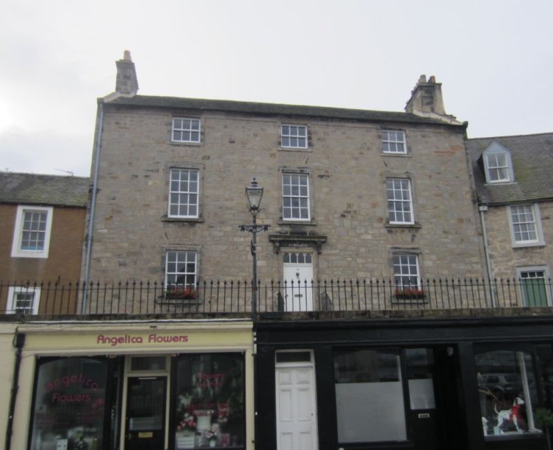
Later 18th century. 3-storey, 3-bay dwelling house. Band course; eaves course. Square and snecked rubble; raised margins; relieving arches to ground and 1st floor windows.
N (PRINCIPAL) ELEVATION: symmetrical elevation; central door; moulded architrave with consoled cornice; fanlight of 4 arched lights; short forestair. Regular fenestration pattern; 2nd floor windows square in proportion; upper lintels integrated with eaves course.
E ELEVATION: adjoining building ground and 1st floor; small window in right bay at 2nd floor.
S ELEVATION: regular fenestration; central door at ground; door in right bay; small attic window.
W ELEVATION: adjoining building.
12-pane sash and case windows; 6-pane sash and case to 2nd floor windows. Slate roof; straight stone skews; rubble stacks at gableheads.
INTERIOR: not seen 2000.
St. Helen's is one of the larger dwelling houses in Queensferry's town centre. The style of the dwelling house is very typical of the period: simple, elegant symmetry in keeping with the fashion for Classical architecture. There are cellars under the house, which are marked as vaults on the 1856 Ordnance Survey Map. These cellars can still be accessed through a door on the High Street. Run-rig garden wall to rear; the run-rig gardens of houses on East Terrace appear on an 18th century map: J Adair, Map of West Lothian, 1737.
External links are from the relevant listing authority and, where applicable, Wikidata. Wikidata IDs may be related buildings as well as this specific building. If you want to add or update a link, you will need to do so by editing the Wikidata entry.


Other nearby listed buildings
