Approximate Location Map
Large Map »
Latitude: 55.9895 / 55°59'22"N
Longitude: -3.394 / 3°23'38"W
OS Eastings: 313134
OS Northings: 678274
OS Grid: NT131782
Mapcode National: GBR 20.VRGN
Mapcode Global: WH6S9.TQZ6
Plus Code: 9C7RXJQ4+RC
Entry Name: Laburnum, 13 East Terrace, High Street, South Queensferry
Listing Name: 13 East Terrace, Laburnum House
Listing Date: 22 February 1971
Category: B
Source: Historic Scotland
Source ID: 395115
Historic Scotland Designation Reference: LB47774
Building Class: Cultural
Also known as: South Queensferry, High Street, 13 East Terrace, Laburnum
ID on this website: 200395115
Location: Edinburgh
County: Edinburgh
Town: Edinburgh
Electoral Ward: Almond
Traditional County: West Lothian
Tagged with: Architectural structure
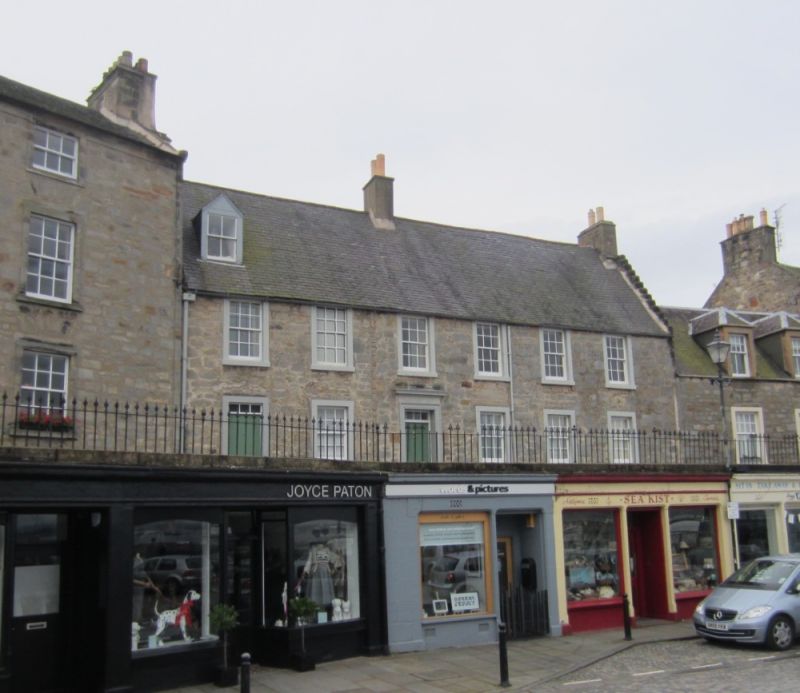
Late 17th century; later alterations and additions. 2-storey and attic, 6-bay dwelling house. Square and snecked rubble to front; raised and painted margins. Band course.
N (PRINCIPAL) ELEVATION: main door in 3rd bay from left; architraved door surround; 4-light fanlight. Door in left bay; plain surround; 3-light fanlight. Regular fenestration pattern; dummy window in 2nd bay from left at 1st floor; gabled attic dormer in left bay.
E ELEVATION: adjoining building.
S ELEVATION: painted; raised margins painted white. Turnpike stair tower at centre with 1st floor window; irregular fenestration; 4 attic dormers; narrow gabled wing to W.
W ELEVATION: adjoining building.
12-pane sash and case timber windows; 4-pane sash and case windows in dormers. Grey slate roof; crowstepped skews; rubble stack at W gablehead; rendered stacks at centre and E gable head.
INTERIOR: not seen 2000.
This is much larger than the other 17th century dwelling houses in Queensferry's town centre and was probably the home of a prosperous family. The 2-entrance principal facade could be misleading but the building is only one dwelling house. The door in the left bay replaced a window. The substitution was made in the early 20th century when the house was shared by 2 sisters who wanted their own entrances to the house. The principal door was used by the married sister and her family; the plainer entrance by the spinster sister. The door in the left bay now opens into the kitchen. Run rig garden at rear; door in garden wall opens onto Stoneycroft Road. The run-rig gardens of houses on East Terrace appear on an 18th century map: J Adair, Map of West Lothian, 1737.
External links are from the relevant listing authority and, where applicable, Wikidata. Wikidata IDs may be related buildings as well as this specific building. If you want to add or update a link, you will need to do so by editing the Wikidata entry.


Other nearby listed buildings
