Latitude: 55.9944 / 55°59'39"N
Longitude: -4.8956 / 4°53'44"W
OS Eastings: 219505
OS Northings: 681717
OS Grid: NS195817
Mapcode National: GBR 06.VB6B
Mapcode Global: WH2M1.RLZJ
Plus Code: 9C7QX4V3+PQ
Entry Name: Blairmore Place (Mixed Use Building At Blairmore Pier)
Listing Name: Blairmore Place (Mixed Use Building at Blairmore Pier)
Listing Date: 4 May 2006
Category: C
Source: Historic Scotland
Source ID: 398430
Historic Scotland Designation Reference: LB50422
Building Class: Cultural
ID on this website: 200398430
Location: Dunoon and Kilmun
County: Argyll and Bute
Electoral Ward: Cowal
Parish: Dunoon And Kilmun
Traditional County: Argyllshire
Tagged with: Architectural structure
Loch Lomond And Trossachs National Park Planning Authority
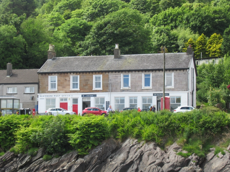
Built c1857 and later extended, this rectangular-plan building with businesses on the ground floor and apartments on the upper floor is the only surviving commercial or mixed use building in Blairmore. The building emphasises the importance of steamer traffic to development there and contributes to the streetscape to form a nucleus for the scattered development along the shore.
Blairmore Place has 6 window bays on the upper floor and a series of simple, large plate-glass shop windows and doors on the ground floor. The rendered ground floor is separated from the upper by a band course. There is little other embellishment, apart from projecting rafters. To the rear, stone steps with cast iron balusters lead to some of the upper flats. From the 1st edition OS map it is evident that the N half of the building was built first and served as the telegraph office. The S half was built later in the 19th century and it is likely that the building was remodelled to provide a matching whole. The same photograph also appears to show 3 small shops and one double-fronted shop to the N. However, since then, a door has been blocked up to form a larger unit - now a café/art gallery (2004).
Interior: access was gained to only parts of the building during the survey (2004). Those areas seen have been modernised.
Materials: sandstone ashlar with raised margins and surrounds to front elevation, rendered to ground floor. Timber boarded double door. Plate glass windows to ground floor, otherwise a variety of window types, including timber sash and case windows. Grey slate roof. Stone stacks with polygonal clay cans.
On earlier photographs a Post Office, Plumber and baker/confectioner are visible. Immediately to the south of this was a larger, gabled 2-3 storey tenement and commercial building, which was replaced c1970 with housing. A number of buildings which appear to the rear of Blairmore Place on the 2nd edition OS map have since become ruinous.
The early use of the building as a telegraph office is important as this was the location of an underwater cable from Cove.
B-Group with Blairmore Hall, Pier and Ticket Office (see separate listings).
External links are from the relevant listing authority and, where applicable, Wikidata. Wikidata IDs may be related buildings as well as this specific building. If you want to add or update a link, you will need to do so by editing the Wikidata entry.


Other nearby listed buildings