Approximate Location Map
Large Map »
Latitude: 53.1977 / 53°11'51"N
Longitude: -3.2287 / 3°13'43"W
OS Eastings: 318013
OS Northings: 367444
OS Grid: SJ180674
Mapcode National: GBR 6W.2G6D
Mapcode Global: WH76Y.CWRF
Plus Code: 9C5R5QXC+3G
Entry Name: Ty Isa
Listing Date: 6 November 1962
Last Amended: 16 October 1995
Grade: II
Source: Cadw
Source ID: 299
Building Class: Domestic
ID on this website: 300000299
Location: Situated 2.2 km NE of Cilcain, reached from a track which runs NE from the by road running S off the A541 to Cilcain.
County: Flintshire
Community: Cilcain
Community: Cilcain
Locality: Cefn (Outlying)
Traditional County: Flintshire
Tagged with: Architectural structure
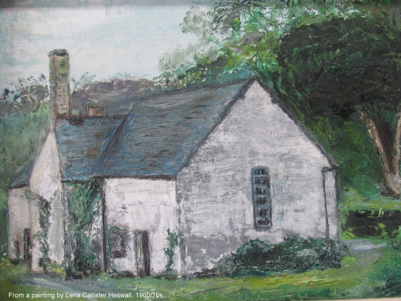
Built probably C16 as a 3-unit hall house with the hall open to the roof, floored over, probably C17. The central truss is illustrated by Smith but not accessible at time of 1995 survey. The plan form and carpentry detail links this house with other local houses of similar date and status. A C19 range with a bread oven was added; refenestrated C19 and C20.
Rubble with roughly squared quoins and some areas of brick to altered openings; slate roof, brick chimneys and a large rubble external stack with brick cap. 2 storeys, 3 unit plan with entrance to former cross passage offset to right, added C19 range to right. All window openings have been altered or added, most have been remodelled using brick. Windows are C19 and C20 with some horizontally-sliding sashes. Left hand return elevation has a window blocked with brickwork and an attached bread oven. Rear elevation has window openings and windows as before including a window inserted into the former cross passage. To the right of this the external stack is gabled with a tall chimney rising above the roof line.
3-unit plan is intact, parlour has chamfered and stopped primary and secondary beams; there are signs of alteration to ceiling which may indicate a stair position. The cross passage is blocked at rear end with an inserted window and has opposed arched entrances from the parlour and to the hall. Timber framed walls are exposed in the hall which has a cambered bressummer over the fireplace, heavy chamfered and stopped primary and secondary beams of inserted ceiling, C20 stair. Plank door with shaped strap hinges to former service area. C19 kitchen added at parlour end has a heavy bressummer in the end wall and cast iron door to bread oven. Upper floor has steps up to the rooms on either side of the hall. The room at the parlour end has exposed timber framing with partially visible truss with king and queen struts and a cambered tie beam. In the stone (former) end wall is a small fireplace of indeterminate date. Above the hall is a timber framed wall with partially visible truss, the offset position relating to the fireplace position below. The room above the services has a similar wall with partially visible queen post truss. Doors upstairs include several plank doors with shaped strap hinges. Roof space not accessible at time of 1995 survey.
Listed as a good and substantially (internally) intact example of a 3-unit hall house which illustrates development to a storeyed hall form.
External links are from the relevant listing authority and, where applicable, Wikidata. Wikidata IDs may be related buildings as well as this specific building. If you want to add or update a link, you will need to do so by editing the Wikidata entry.


Other nearby listed buildings
