Approximate Location Map
Large Map »
Latitude: 53.2724 / 53°16'20"N
Longitude: -3.2193 / 3°13'9"W
OS Eastings: 318786
OS Northings: 375739
OS Grid: SJ187757
Mapcode National: GBR 5ZYL.TN
Mapcode Global: WH76R.J07M
Plus Code: 9C5R7QCJ+X7
Entry Name: Tabernacle English Congregational Church
Listing Date: 19 August 1991
Last Amended: 19 August 1991
Grade: II
Source: Cadw
Source ID: 415
Building Class: Religious, Ritual and Funerary
Also known as: Tabernacle English Congregational Church, Coleshill Street
ID on this website: 300000415
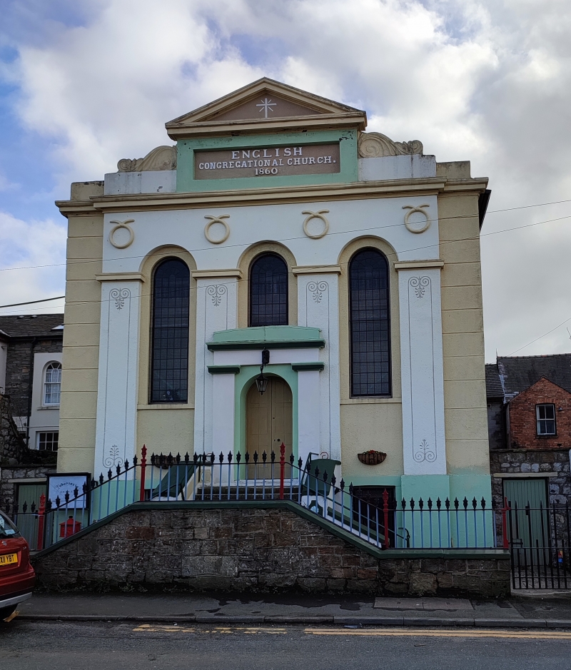
Location: Set back from the road behind walled and railed forecourt with pedimented end piers.
County: Flintshire
Community: Holywell (Treffynnon)
Community: Holywell
Built-Up Area: Holywell
Traditional County: Flintshire
Tagged with: Church building Chapel
Dated 1860.
Unusual Classical 3-bay roughcast facade. Parapet with central pediment over inscribed and dated panel flanked by volutes. Crucifix within pediment recess; overall cornice below. Set back at either end of the facade are channelled pilasters and above the windows are 4 symbols (? evangelism, ? eternity). 3-tall, round arched headed windows in stepped recesses with leaded small-pane glazing; impost bands over pilasters incised with Grecian ornament. Stout central doorcase with pilasters and parapet; round arched entry and panelled doors; T-plan staircase up to entrance. Basement windows below. Leaded small-pane square headed windows to 4-window right hand side screened by side gateway; similar detail to left hand side.
Group value with Nos 10 and 12 and the Masonic Hall.
External links are from the relevant listing authority and, where applicable, Wikidata. Wikidata IDs may be related buildings as well as this specific building. If you want to add or update a link, you will need to do so by editing the Wikidata entry.


Other nearby listed buildings
