Latitude: 53.2723 / 53°16'20"N
Longitude: -3.2191 / 3°13'8"W
OS Eastings: 318794
OS Northings: 375727
OS Grid: SJ187757
Mapcode National: GBR 5ZYL.VP
Mapcode Global: WH76R.J09Q
Plus Code: 9C5R7QCJ+W8
Entry Name: Maes-Y-Dre
Listing Date: 19 August 1991
Last Amended: 19 August 1991
Grade: II
Source: Cadw
Source ID: 416
Building Class: Domestic
ID on this website: 300000416
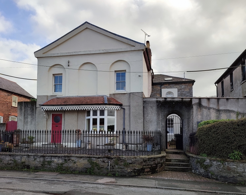
Location: Set back behind raised forecourt with railings curving around at ends, at right running back towards screen wall linking No 10 and the neighbouring chapel; round arched entrance to courtyard of Maes-y
County: Flintshire
Community: Holywell (Treffynnon)
Community: Holywell
Built-Up Area: Holywell
Traditional County: Flintshire
Tagged with: Building
Built in 1838 by John Welch as a Savings Bank incorporating Manager's Offices at the rear. C20 (inter-war?) conversion into domestic accommodation; 'T'-plan.
Classical, 2-storey, 3-bay front; rendered to 1st floor, pebbledash below sill band. Slate roof, boarded eaves and rebuilt brick chimney stacks. The facade is composed of pediment over 3-round arched full height recesses, the outer of which contain 4-pane horned sash windows to 1st floor. Later alterations to ground floor; splayed and bracketed canopy with valencing containing casement glazed splayed bay and door offset to left. 3-bay left hand side with horned 4-pane sashes. Rubble transverse range with hipped slate roof; to left is 1-semicircular headed small-pane sash in unusually broad architrave. 2-storey, 4-window rubble rear with broad margins to small-pane sashes; central windows linked by ornamental panel (?formerly containing a plaque).
Listed as an unusually early bank building.
Group value with the English Congregational Church and the Masonic Hall.
External links are from the relevant listing authority and, where applicable, Wikidata. Wikidata IDs may be related buildings as well as this specific building. If you want to add or update a link, you will need to do so by editing the Wikidata entry.


Other nearby listed buildings