Approximate Location Map
Large Map »
Latitude: 53.272 / 53°16'19"N
Longitude: -3.2198 / 3°13'11"W
OS Eastings: 318751
OS Northings: 375698
OS Grid: SJ187756
Mapcode National: GBR 5ZYL.QS
Mapcode Global: WH76R.H0ZX
Plus Code: 9C5R7QCJ+R3
Entry Name: Holywell County Court
Listing Date: 19 August 1991
Last Amended: 19 August 1991
Grade: II
Source: Cadw
Source ID: 431
Building Class: Civil
ID on this website: 300000431
Location: Detached forward to the street.
County: Flintshire
Community: Holywell (Treffynnon)
Community: Holywell
Built-Up Area: Holywell
Traditional County: Flintshire
Tagged with: Architectural structure
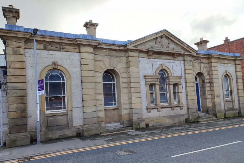
Built in 1855; similar design to that of the Court House at St Asaph (1853)
Symmetrical, Italianate Classical, single storey, 5-bay front. Grey masonry in random courses liberally faced with golden freestone dressings including advanced and channelled pilasters flanking each bay; cornice, frieze and plinth, the latter stepped out below outer windows. Low hipped roof with overall leaded parapet and freestone chimney stacks to ends with bracket cornices and swept out bases. Central bay has pediment containing royal arms.
Round-headed openings; sash windows with marginal glazing bars. Venetian window to centre with keystone, pilasters and bracketed sill. Flanking bays have rusticated surrounds to recessed doorways with steps; that to left is blocked by insertion of similar window; 6-panel door to right with plain fanlight. Windows to outer bays have keystones to tall architraves including panelled aprons. Side elevations have paired channelled end pilasters. Taller hipped roof range behind with simpler detail and central stack to the front. Internally the Court Room retains dais over Judges panelled bench.
Listed as a fine mid C19 public building.
External links are from the relevant listing authority and, where applicable, Wikidata. Wikidata IDs may be related buildings as well as this specific building. If you want to add or update a link, you will need to do so by editing the Wikidata entry.


Other nearby listed buildings
