Approximate Location Map
Large Map »
Latitude: 53.2886 / 53°17'18"N
Longitude: -3.21 / 3°12'36"W
OS Eastings: 319434
OS Northings: 377530
OS Grid: SJ194775
Mapcode National: GBR 6Z0D.VV
Mapcode Global: WH76K.NLMR
Plus Code: 9C5R7QQQ+CX
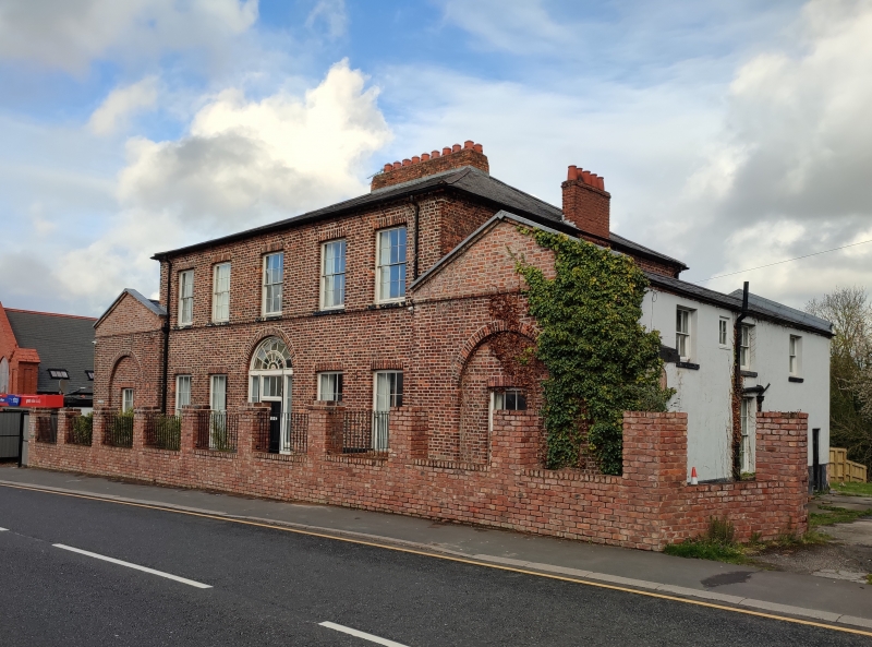
Entry Name: The Surgery
Listing Date: 19 August 1991
Last Amended: 19 August 1991
Grade: II
Source: Cadw
Source ID: 508
Building Class: Health and Welfare
ID on this website: 300000508
Location: Set back slightly from the road; detached.
County: Flintshire
Community: Holywell (Treffynnon)
Community: Holywell
Locality: Greenfield
Built-Up Area: Holywell
Traditional County: Flintshire
Tagged with: Architectural structure
ca 1800;
2-storeys with single storey wings. Red brick with hipped slate main roof and broad brick chimney stack. Symmetrical front with plinth and sill band; 12-pane sash windows, taller to ground floor. Tall arched central entrance with voussoirs and fine traceried fanlight; sidlights and 6-panel door. Stepped forward slightly are the flanking wings, possibly originally coach-houses. Gables to the front given simple pediment treatment with ornamental diamond motifs; tall arched recesses to each. Tiled roof to left wing with 3-window side elevation including sashes and central entrance.
Slate roof to right wing with modern windows and attached monopitch range.
Similar to rear.
Altered interior retains simple Georgian curved staircase.
Listed as a particularly fine building of its kind, demonstrating the importance and prosperity of Greenfield in late C18/early C19.
External links are from the relevant listing authority and, where applicable, Wikidata. Wikidata IDs may be related buildings as well as this specific building. If you want to add or update a link, you will need to do so by editing the Wikidata entry.


Other nearby listed buildings
