Latitude: 53.1297 / 53°7'46"N
Longitude: -3.2644 / 3°15'51"W
OS Eastings: 315493
OS Northings: 359919
OS Grid: SJ154599
Mapcode National: GBR 6T.6ZF9
Mapcode Global: WH779.TLPK
Plus Code: 9C5R4PHP+V6
Entry Name: Halfway House
Listing Date: 19 July 1966
Last Amended: 24 June 1999
Grade: II
Source: Cadw
Source ID: 743
Building Class: Domestic
ID on this website: 300000743
Location: On a commanding site high up on the slopes of Foel Fenlli overlooking the Vale of Clwyd, approximately 1.2 Km NE of Llanbedr village; accessed via an unclassified lane running E off the A 494 Ruthin-M
County: Denbighshire
Town: Ruthin
Community: Llanbedr Dyffryn Clwyd
Community: Llanbedr Dyffryn Clwyd
Locality: Foel Fenlli
Traditional County: Denbighshire
Tagged with: House
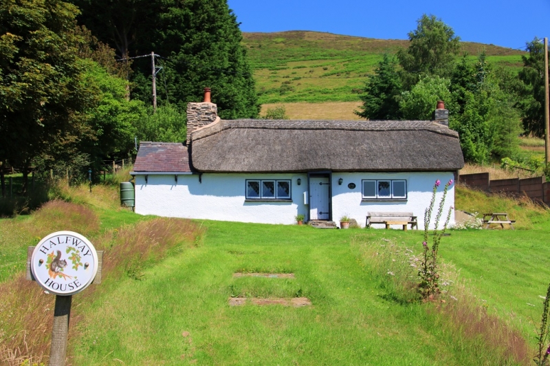
C18 cottage located on the old road accross Moel Fenlli; C20 additions to the L and rear.
C18 single-storey vernacular cottage of rubble construction with thatched roof; roughcast front and whitened rubble rear. Squat rubble chimney to the L, widened by the addition of an adjoining flue, serving a small slated C20 addition flush to the L; modern slate chimney to R gable end. Central entrance via 2 composite rubble steps; C20 boarded door with simple boarded wind porch. C20 three-light wooden leaded casement windows flank the entrance, with projecting tiled sills; similar window to L gable of the addition. Small primary light with plain glazing to rear. A modern rendered extension adjoins to the rear of the addition.
Three-bay cottage with 2-bay hall space to L and single-bay chamber to R, the former with a crude bressummer to its fireplace.
Listed, notwithstanding altered detail, for its special interest as a good regional example of an C18 vernacular house retaining thatched roof.
External links are from the relevant listing authority and, where applicable, Wikidata. Wikidata IDs may be related buildings as well as this specific building. If you want to add or update a link, you will need to do so by editing the Wikidata entry.


Other nearby listed buildings