Approximate Location Map
Large Map »
Latitude: 53.1067 / 53°6'24"N
Longitude: -2.9505 / 2°57'1"W
OS Eastings: 336462
OS Northings: 357035
OS Grid: SJ364570
Mapcode National: GBR 77.89SP
Mapcode Global: WH88S.N55N
Plus Code: 9C5V424X+MQ
Entry Name: Rossett Mill
Listing Date: 9 June 1952
Last Amended: 18 October 1996
Grade: II*
Source: Cadw
Source ID: 1530
Building Class: Industrial
ID on this website: 300001530
Location: Situated slightly back from the north-west of the B 5102 Chester Road and to the north of the main village of Rossett. Stands in its own grounds with new stable developments to the rear south of the A
County: Wrexham
Community: Rossett (Yr Orsedd)
Community: Rossett
Built-Up Area: Rossett
Traditional County: Denbighshire
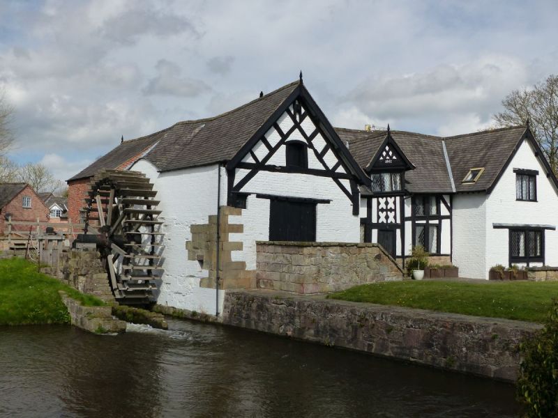
A mill for the villagers of Allington, Gresford, Burton, and Llay was first built on this site in 1544. Intended as a "free" mill to rival the King's Mill at Marford on the opposite side of the road, the original mill was demolished sometime within the next forty years. A new mill, the current building, was built in 1588, and extended in 1661 around which time Sir John Trevor of Trevalyn Hall acquired both mills. In 1710 the millwright Robert Konrick undertook extensive repairs to the floors and waterwall. Further extension took place in the 1820's. The mill was sketched by Turner in 1795.
Two storeys, on an accretative H-plan with timber box-framed central section, and limited stone dressings on irregular stone base. Pitch slate roof with new skylights. The earliest part of the mill, to the north dating from 1588, houses the driving machinery including pit wheel, wallower, and large spur wheel. Newly formed stone steps up to former cart entrance and large stone quoins. Roof braces exposed to gable end. Central section of 1661 is box-frame on stone plinth with dated dormer over porch. Quatrefoil timber decoration over main door. Western section is 19th century, of brick construction with filled-in cart door to form window. Single storey extension to west cross-wing.
Internal inspection not possible at time of re-survey in 1995.
Listed as an exceptionally fine example of a 16th century timber-framed undershot corn mill.
External links are from the relevant listing authority and, where applicable, Wikidata. Wikidata IDs may be related buildings as well as this specific building. If you want to add or update a link, you will need to do so by editing the Wikidata entry.


Other nearby listed buildings
