Approximate Location Map
Large Map »
Latitude: 52.9867 / 52°59'12"N
Longitude: -3.0404 / 3°2'25"W
OS Eastings: 330253
OS Northings: 343766
OS Grid: SJ302437
Mapcode National: GBR 73.HZZ7
Mapcode Global: WH89B.86F5
Plus Code: 9C4RXXP5+MR
Entry Name: Round House
Listing Date: 7 June 1963
Last Amended: 22 February 1995
Grade: II
Source: Cadw
Source ID: 1623
Building Class: Civil
ID on this website: 300001623
Location: Situated at the SW angle of St Mary's churchyard.
County: Wrexham
Community: Ruabon (Rhiwabon)
Community: Ruabon
Built-Up Area: Ruabon
Traditional County: Denbighshire
Tagged with: Architectural structure Village lock-up
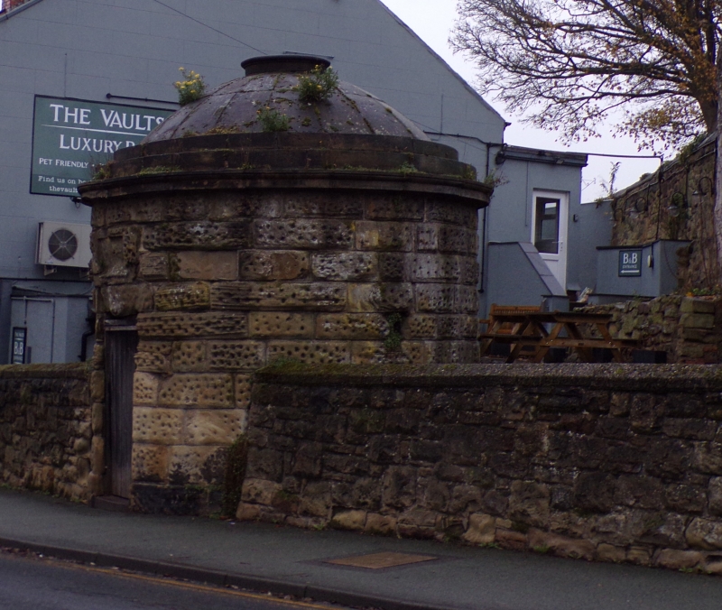
Later C18 circular structure, probably a parish lock-up. Squared pecked sandstone blocks, ashlar cornice and domed roof with central lipped opening in the dome. Small openings in sides have iron bars. Door to street of C20 character.
Listed for its special interest as a scarce example of an C18 structure, probably a parish lock-up, which is in relatively unaltered condition.
External links are from the relevant listing authority and, where applicable, Wikidata. Wikidata IDs may be related buildings as well as this specific building. If you want to add or update a link, you will need to do so by editing the Wikidata entry.


Other nearby listed buildings
