Approximate Location Map
Large Map »
Latitude: 51.6804 / 51°40'49"N
Longitude: -3.1647 / 3°9'53"W
OS Eastings: 319566
OS Northings: 198599
OS Grid: ST195985
Mapcode National: GBR HY.5BNL
Mapcode Global: VH6DG.3184
Plus Code: 9C3RMRJP+54
Entry Name: Former Barn at Croespenmaen
Listing Date: 19 April 1963
Last Amended: 29 January 1999
Grade: II
Source: Cadw
Source ID: 1885
Building Class: Agriculture and Subsistence
ID on this website: 300001885
Location: In the hilltop community of Croespenmaen just S of the crossroads with the A 4251.
County: Caerphilly
Community: Crumlin (Crymlyn)
Community: Crumlin
Locality: Croespenmaen
Built-Up Area: Blackwood
Traditional County: Monmouthshire
Tagged with: Barn
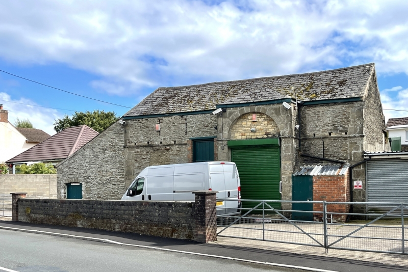
Probably mostly early C19, appears on Tithe Map 1846. Formerly divided into cowbyre with hayloft above to left, and barn right. Croespenmaen Farm to which barn originally belonged burned down in 1947. Now used as feed merchants' shop.
Tall barn of stone rubble with tooled ashlar dressings; shallow pitched Welsh slate roof to front, catslide to rear over lower outshut. Centre right full- height hipped-roof porch with high round-arched doorway with voussoirs, keystone and imposts, the keystone at eaves level; arch head blocked above impost level; double boarded doors. To sides short ventilation slits below eaves and dove nesting holes with ledge below. To left a large boarded loft opening and to ground floor 2 cambered-arched doorways, one part blocked. Added wing with long sloping roof and further openings to left.
Interior retains stone threshing floor. First floor rear opening to outshut which has divided interior. No internal divisions or lofts remain within barn which is now used as a shop and store.
Listed as an unusually well-designed small early C19 barn.
External links are from the relevant listing authority and, where applicable, Wikidata. Wikidata IDs may be related buildings as well as this specific building. If you want to add or update a link, you will need to do so by editing the Wikidata entry.


Other nearby listed buildings
