History in Structure

Sundial with railings in Churchyard of Church of St. Mary

A Grade II Listed Building in Monmouth, Monmouthshire

More Photos »
Approximate Location Map
Large Map »

Coordinates

Latitude: 51.813 / 51°48'46"N

Longitude: -2.7141 / 2°42'50"W

OS Eastings: 350870

OS Northings: 212952

OS Grid: SO508129

Mapcode National: GBR FL.WTNG

Mapcode Global: VH86T.XP1H

Plus Code: 9C3VR77P+69

Entry Name: Sundial with railings in Churchyard of Church of St. Mary

Listing Date: 15 August 1974

Last Amended: 10 August 2005

Grade: II

Source: Cadw

Source ID: 2213

Building Class: Gardens, Parks and Urban Spaces

ID on this website: 300002213

Location: Immediately south of the south-west corner of the Church of St. Mary.

County: Monmouthshire

Town: Monmouth

Community: Monmouth (Trefynwy)

Community: Monmouth

Built-Up Area: Monmouth

Traditional County: Monmouthshire

Tagged with: Sundial

Find accommodation in
Monmouth

History

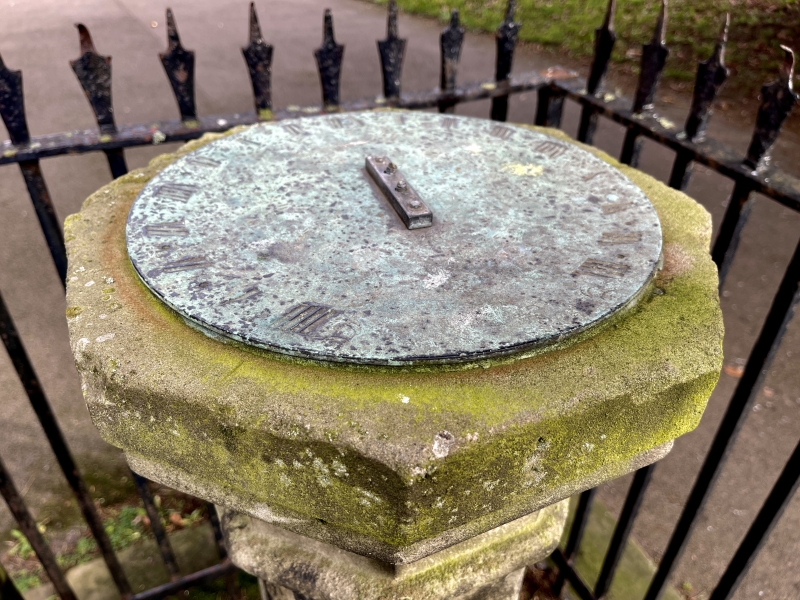
Probably early C19 sundial but perhaps repositioned when the church was rebuilt, the railings are also C19.

Exterior

Stone baluster on a square plinth, The baluster is turned and moulded at the base and then decreases to an octagonal shaft which has a moulded cap. This carries the brass sundial which is missing the gnomon. The whole stands on two low square steps and is surrounded by wrought iron spike railings with cast vases on the corner standards.

Reasons for Listing

Included for its special historic interest close to the principal church in Monmouth.

External Links

External links are from the relevant listing authority and, where applicable, Wikidata. Wikidata IDs may be related buildings as well as this specific building. If you want to add or update a link, you will need to do so by editing the Wikidata entry.

Recommended Books

Other nearby listed buildings

  • II Memorial to Charles Heath in Churchyard of Church of St. Mary
    Immediately inside the main gate into the churchyard of the Church of St. Mary.
  • II NO.24 Church Street, Gwent
    At the churchyard end of a continuous range of buildings running through from Agincourt Square. Side and rear elevations overlook St.Mary's Churchyard with gateway pilaster attached.
  • II* Church of St. Mary
    On the street continuing Church Street east out of the town centre.
  • II 22, Church Street
    In the street leading north-east out of the town square in the centre of Monmouth.
  • II 20, Church Street
    In the street leading north-east out of the town square in the centre of Monmouth.
  • II 23, Church Street
    In the street leading north-east out of the town square in the centre of Monmouth. It occupies the corner site with St. Mary's Street opposite the entrance to St. Mary's churchyard.
  • II 5, Whitecross Street
    On the street continuing Church Street east out of the town centre.
  • II The Griffin PH
    On the street continuing Church Street east out of the town centre. At the foot of the Public House walls is a rare surviving example of a hollowed sandstone gutter which goes round the street corner.

BritishListedBuildings.co.uk is an independent online resource and is not associated with any government department. All government data published here is used under licence. Please do not contact BritishListedBuildings.co.uk for any queries related to any individual listed building, planning permission related to listed buildings or the listing process itself.

British Listed Buildings is a Good Stuff website.