Latitude: 51.5968 / 51°35'48"N
Longitude: -2.7483 / 2°44'54"W
OS Eastings: 348260
OS Northings: 188930
OS Grid: ST482889
Mapcode National: GBR JJ.BMD8
Mapcode Global: VH87Z.94X6
Plus Code: 9C3VH7W2+PM
Entry Name: Upper House
Listing Date: 28 October 1976
Last Amended: 8 August 2000
Grade: II
Source: Cadw
Source ID: 2738
Building Class: Domestic
ID on this website: 300002738
Location: About 300m north of the Church of St Mary on the old road to Caerwent, now by-passed.
County: Monmouthshire
Town: Newport
Community: Caldicot
Community: Caldicot
Built-Up Area: Cil-y-coed
Traditional County: Monmouthshire
Tagged with: House
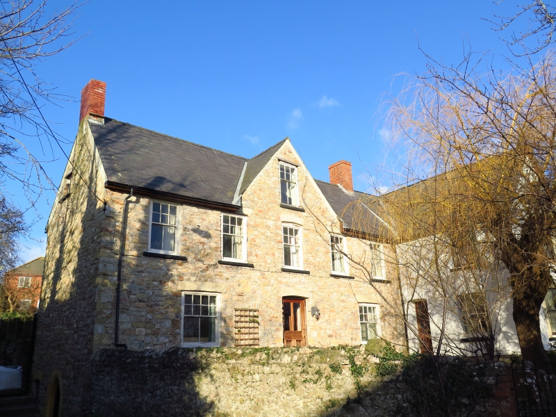
The south-west wing is apparently of C16 origin with probably C17 alterations and with late C19 refurbishing, but the building has been so changed that interpretation is very difficult. It may be that the C16 house was a small 2-cell one which was enlarged and heightened in the C17. This view is confirmed by RCAHMW which describes it as an A-type house. There is a late C19 cross-wing at the north-east end. The whole gives the appearance of being a C17 hall-and-cross-wing house but the evidence available at resurvey is inconclusive.
The house is rendered, presumably over rubble stone, only the quoins on the north east gable are revealed, but the later wing could well be of brick, Welsh slate roofs. The front elevation of the south-west (earlier) wing is of two storeys and attics and five bays, with a gabled roof with flanking stacks. Five sash windows on the first floor with the glazing bars in upper parts only and with a cambered head to the centre window; centre attic sash with gable over. On the ground floor, a sash window with glazing bars in upper part only to each side of a central cambered headed doorway with half-glazed panelled door. All these features are late C19.
The south-west elevation to the road has a chamfered pointed stone doorway of C16 type to the cellar which has the original boarded door cut down as the ground level has risen considerably. The wall is blind above this apart from a small garret window with casement. Red brick stack on the gable above.The cross-wing to the right of the main elevation has quoins to the south-east gable end and a 2-storeyed canted bay window with slate roof and plate glass sashes. Plain bargeboards to the gable end, red brick stack on right hand elevation which also has a modern atttached porch and a sash window above, small extension, also with quoins, to the rear. The rear elevation of the house was not seen at resurvey.
Only partially seen at time of resurvey. On the ground floor the north-east room has a large chimney breast with the fireplace removed, and with a stopped and chamfered centre beam of minor importance. Similar beam in left hand ground floor room. Replacement staircase. There are also said to be stopped beams in the first floor rooms and mainly modern roof trusses, while the cellar room has a double ceiling with stopped and chamfered centre beam, but none of these were seen at resurvey.
Listed as an interesting survival of an C16 house later extended and adapted which, despite alteration, retains a number of ancient features.
External links are from the relevant listing authority and, where applicable, Wikidata. Wikidata IDs may be related buildings as well as this specific building. If you want to add or update a link, you will need to do so by editing the Wikidata entry.


Other nearby listed buildings