Approximate Location Map
Large Map »
Latitude: 53.0955 / 53°5'43"N
Longitude: -4.1883 / 4°11'17"W
OS Eastings: 253571
OS Northings: 357603
OS Grid: SH535576
Mapcode National: GBR 5M.9326
Mapcode Global: WH54S.MGS8
Plus Code: 9C5Q3RW6+5M
Entry Name: Church of St Garmon
Listing Date: 29 May 1968
Last Amended: 29 January 1999
Grade: II
Source: Cadw
Source ID: 3754
Building Class: Religious, Ritual and Funerary
Also known as: Church of St Garmon, Betws Garmon
St Garmon's Church, Betws Garmon
ID on this website: 300003754
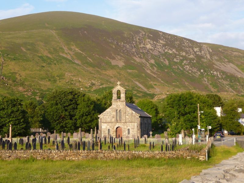
Location: Located on level ground in a low rubblestone-walled rectangular churchyard on the north side of the A 4085 at Betws Garmon.
County: Gwynedd
Town: Caernarfon
Community: Betws Garmon
Community: Betws Garmon
Traditional County: Caernarfonshire
Tagged with: Church building
Built in 1841-2 by George Alexander near the site of the old church, the west end of which appears to have been where the present chancel is.
Parish church. Romanesque style. Regularly coursed and dressed rubblestone blocks with ashlar dressings; slate roofs with coped verges and kneelers to nave, conical to semi-circular sanctuary. Nave in 3 bays with 2 stepped buttresses to north and south walls and diagonal buttresses to corners. 2-light round-arched cast-iron latticed windows with plain chamfered shafts and capitals in round-headed openings linked by continuous impost banding. West end has central round-headed doorway with date "1842" to top and recessed boarded door; narrow round-headed windows to either side linked by continuous impost band. String course above with slightly projecting break to centre of the wall, housing a 2-light window like those to north and south walls, continues up to form gabled bellcote with round-headed opening; this has extrados, imposts and a bell. Semi-circular apsidal sanctuary has 3 small round-headed windows linked by continuous cill and impost bands; red stained glass to outer quarries.
Simple interior has collar and tie beam roof structure with boarding to the rafters; half-height screen forms small internal lobby at west end; slate floor. Plain C19 fittings include rail to raised sanctuary, pulpit, reading desk and benches. C17 communion table with C20 top; font with carved lettering and date "CAPEL. SANT. GARMON. BETWS. 1614" also from old church has a small 4-leaved flower carved between "CAPEL" and the date. C18 wall tablets and a brass on north wall to John Rowlands (d.1703).
Included as an unaltered mid-C19 church, an unusual essay in Romanesque style forming a prominent local landmark.
External links are from the relevant listing authority and, where applicable, Wikidata. Wikidata IDs may be related buildings as well as this specific building. If you want to add or update a link, you will need to do so by editing the Wikidata entry.


Other nearby listed buildings
