Approximate Location Map
Large Map »
Latitude: 52.8046 / 52°48'16"N
Longitude: -4.7119 / 4°42'42"W
OS Eastings: 217293
OS Northings: 326450
OS Grid: SH172264
Mapcode National: GBR GPR8.SJB
Mapcode Global: WH33M.LRGT
Plus Code: 9C4QR73Q+R6
Entry Name: Pont Fach
Listing Date: 19 October 1971
Last Amended: 26 June 1998
Grade: II
Source: Cadw
Source ID: 4228
Building Class: Transport
ID on this website: 300004228
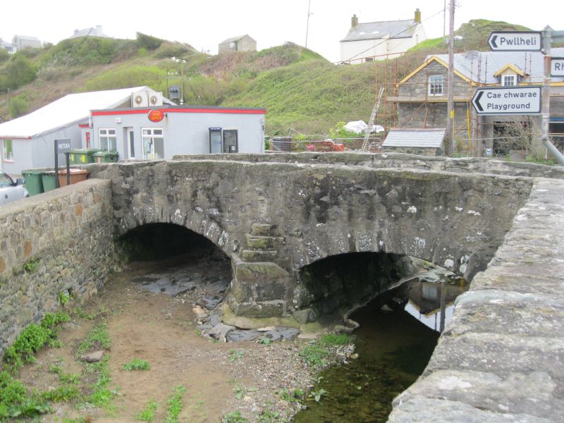
Location: Situated at the centre of Aberdaron, N of Pont Fawr, carrying road to Pwllheli.
County: Gwynedd
Town: Pwllheli
Community: Aberdaron
Community: Aberdaron
Traditional County: Caernarfonshire
Tagged with: Bridge Road bridge
Road bridge, dated 1823, over the Cyll-y-felin stream at its junction with the Afon Daron.
Road bridge, rubble stone with two low arches, segmental with stone voussoirs, one voussoir on SW arch dated 1823. Plain low pier between arches. Rubble parapets with slab copings, the S parapet extending W to join parapet of Pont Fach (q.v.).
An early C19 road bridge of group value with Pont Fawr, the two bridges forming a focal point in the centre of Aberdaron.
External links are from the relevant listing authority and, where applicable, Wikidata. Wikidata IDs may be related buildings as well as this specific building. If you want to add or update a link, you will need to do so by editing the Wikidata entry.


Other nearby listed buildings
