Approximate Location Map
Large Map »
Latitude: 52.8114 / 52°48'41"N
Longitude: -4.7107 / 4°42'38"W
OS Eastings: 217404
OS Northings: 327209
OS Grid: SH174272
Mapcode National: GBR GPR8.6ZL
Mapcode Global: WH33M.ML1K
Plus Code: 9C4QR76Q+HP
Entry Name: Bodernabwy
Listing Date: 19 October 1971
Last Amended: 26 June 1998
Grade: II
Source: Cadw
Source ID: 4231
Building Class: Domestic
ID on this website: 300004231
Location: N of Aberdaron village, on the S side of a lane which crosses Nant Eiddon some 1km N of the village.
County: Gwynedd
Town: Pwllheli
Community: Aberdaron
Community: Aberdaron
Traditional County: Caernarfonshire
Tagged with: Building
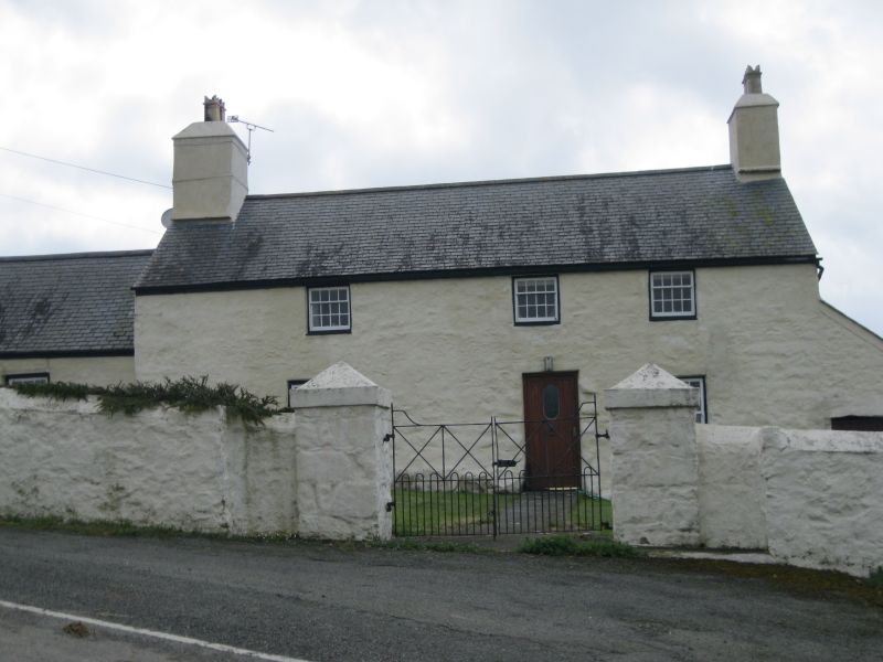
Farmhouse, possibly earlier C18 with earlier C19 windows. Marked on 1844 Tithe Map as a farm of 70 acres (28.3ha), owned by the Cefn Amwlch estate, occupied by Owen Jones.
Farmhouse, colour-washed rubble stone with slate roof and whitewashed end stacks, much larger to left. Two-storey, three-window front much offset to right. Three first floor square windows under eaves, two left of centre, one right. 12-pane hornless glazing. Ground floor has larger 16-pane hornless sashes, roughly under the outer windows of upper floor, but left window not quite aligned. C20 door, jambs have rough projecting stones. Lean-to cartshed on right end with curved corner and broad opening. Single storey outbuilding uphill to left with 3 windows. Rear wing to house with end stack, 16-pane sash and door.
Not available for inspection but said to have two encased beams, and a small visible part of the W beam to show some moulding that may be the top rail of a post and panel screen.
Included as a good and little-altered example of a traditional farmhouse.
External links are from the relevant listing authority and, where applicable, Wikidata. Wikidata IDs may be related buildings as well as this specific building. If you want to add or update a link, you will need to do so by editing the Wikidata entry.


Other nearby listed buildings
