Latitude: 52.8626 / 52°51'45"N
Longitude: -3.7025 / 3°42'9"W
OS Eastings: 285478
OS Northings: 330815
OS Grid: SH854308
Mapcode National: GBR 68.RM2X
Mapcode Global: WH67B.395T
Plus Code: 9C4RV77W+2X
Entry Name: 1-6 Glanlliw, including associated coal stores to E and W
Listing Date: 20 October 1966
Last Amended: 31 January 2001
Grade: II
Source: Cadw
Source ID: 4686
Building Class: Institutional
ID on this website: 300004686
Location: Located at the eastern approach of the hamlet of Dolhendre, on the S side of the lane running eastwards to join the trunk road immediatey N of Llanuwchllyn village.
County: Gwynedd
Town: Bala
Community: Llanuwchllyn
Community: Llanuwchllyn
Locality: Dolhendre
Traditional County: Merionethshire
Tagged with: Building
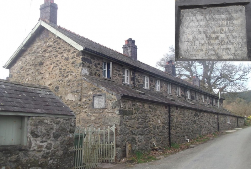
The Dolhendre almshouses were founded in 1721 by the Rev Maurice Vaughan of Caer Gai, Canon of Windsor. The foundation provided for the relief of 6 old people of the parish and was endowed with 2 tenements, Ty Mawr and Ty'n y Cae farms, together with the interest on £200 for continuing maintenance. A slate inscription plaque on the building places the actual erection of the building in 1731. In the late C19 the almshouses were extensively restored, being raised from one storey to two and being given a continuous lean-to extension to the rear. External porches were added during a further restoration in 1959. Whilst the accommodation consisted of 6 units from the C19 onwards, it appears that formerly there were only 3 units, suggesting that the original inhabitants were three married couples.
Two-storey former almshouse range consisting of six one-window units. Of slatestone rubble construction under a continuous slate roof with tiled ridge and oversailing verges; plain bargeboards. Four late C19 brick chimneys with pots. The units are arranged as three reflected pairs and face SE with the rear backing onto the road. The front elevation has paired entrances to each of the three pairs now contained within single-storey roughcast lean-to porches; side entrances to these. Four-pane late C19 casement windows to both floors, those to the first floor larger. The road-facing rear elevation has a continuous slated lean-to which returns to wrap around the SW gable end; 6 modern skylights to this, together with a modern window to the penultimate south-eastern unit. The original slate dedication plaque is inset in the NE end wall of the lean-to addition (relocated in the late C19). Two windows as before to each unit on the first floor.
Adjacent to the almshouse range at either end are single-storey coal shed blocks contemporary with the late C19 remodelling. These are of rubble construction with slate roofs and engineering brick quoins to plain boarded doors.
The interior was not inspected at the time of survey.
Listed as an essentially late C19 cottage row, the rebuilding of an earlier, second-quarter C18 almshouse complex, retaining strong vernacular character.
External links are from the relevant listing authority and, where applicable, Wikidata. Wikidata IDs may be related buildings as well as this specific building. If you want to add or update a link, you will need to do so by editing the Wikidata entry.


Other nearby listed buildings