History in Structure

Pont Cymmerau

A Grade II Listed Building in Ffestiniog, Gwynedd

More Photos »
Approximate Location Map
Large Map »

Coordinates

Latitude: 52.969 / 52°58'8"N

Longitude: -3.9508 / 3°57'2"W

OS Eastings: 269087

OS Northings: 343072

OS Grid: SH690430

Mapcode National: GBR 5Y.JSXB

Mapcode Global: WH55H.8MXS

Plus Code: 9C4RX29X+HM

Entry Name: Pont Cymmerau

Listing Date: 24 April 1951

Last Amended: 1 February 1996

Grade: II

Source: Cadw

Source ID: 4692

Building Class: Transport

ID on this website: 300004692

Location: Located about 1km N of Rhyd-y-sarn in a wood fording the Afon Goedol; accessed via a track leading W from the A 496.

County: Gwynedd

Community: Ffestiniog

Community: Ffestiniog

Locality: Pont Cymmerau

Traditional County: Merionethshire

Tagged with: Bridge

Find accommodation in
Tanygrisiau

Exterior

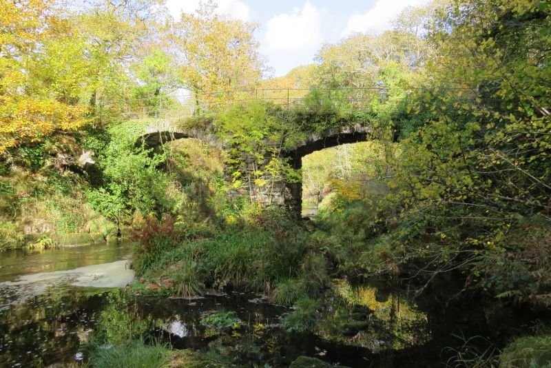
Description: 2-span vernacular bridge, perhaps C17 and said to be at the junction of several Roman roads. Rubble construction on rock platform; 2 wide segmental arches with arch rings. Shallow-pointed cut-water on upstream side and flat buttress on downstream side. The R arch is set slightly lower; no parapets and out-of-character modern wire fence.

A vernacular twin-arched bridge of historic interest.

External Links

External links are from the relevant listing authority and, where applicable, Wikidata. Wikidata IDs may be related buildings as well as this specific building. If you want to add or update a link, you will need to do so by editing the Wikidata entry.

Recommended Books

Other nearby listed buildings

  • II* Pengwern Old Hall
    Located on a rise overlooking the Ceunant Sych approximately 2km N of Ffestiniog; accessed via a farm track leading W off an unclassified lane connecting the A 470 with the A 496.
  • II Bwlch-Iocyn
    Located on a rise some 3km NW of Ffestiniog; accessed via a long track leading NW off the main road. Set in a rubble-walled garden on a slightly raised, stone-flagged terrace.
  • II Penralltgoch
    Located approximately 0.5km W of Ffestiniog village on a slightly raised terrace on the steep roadside.
  • II Plas Dol-y-moch
    On the narrow country road that runs along the N side of the Vale of Ffestiniog between the A487(T) and the B4391; ENE of Maentwrog.
  • II Peniel Chapel (including hall addition to rear)
    Located approximately 91m NW of the A 470 in the centre of the village; set back behind contemporary decorative railings on a slightly raised, part-metalled terrace and accessed from the road via a sh
  • II Church of St Michael
    On a promontory of high ground at the western end of Llan Ffestiniog, set back slightly from the informal village square.
  • II Pengwern Arms Hotel
    Facing the square prominently to the N.
  • II Bridge c200m W of Pont y Pandy
    Situated c200m W of the modern Pont y Pandy on the A470, carrying a minor road over the Afon Teigl, N of Ty Mari Williams.

BritishListedBuildings.co.uk is an independent online resource and is not associated with any government department. All government data published here is used under licence. Please do not contact BritishListedBuildings.co.uk for any queries related to any individual listed building, planning permission related to listed buildings or the listing process itself.

British Listed Buildings is a Good Stuff website.