History in Structure

Lych gate and churchyard wall at Llangelynin church

A Grade II Listed Building in Llangelynin, Gwynedd

More Photos »
Approximate Location Map
Large Map »

Coordinates

Latitude: 52.6437 / 52°38'37"N

Longitude: -4.1125 / 4°6'44"W

OS Eastings: 257168

OS Northings: 307205

OS Grid: SH571072

Mapcode National: GBR 8Q.6J2Z

Mapcode Global: WH56Y.STW3

Plus Code: 9C4QJVVQ+F2

Entry Name: Lych gate and churchyard wall at Llangelynin church

Listing Date: 17 June 1966

Last Amended: 7 June 2005

Grade: II

Source: Cadw

Source ID: 4752

Building Class: Religious, Ritual and Funerary

ID on this website: 300004752

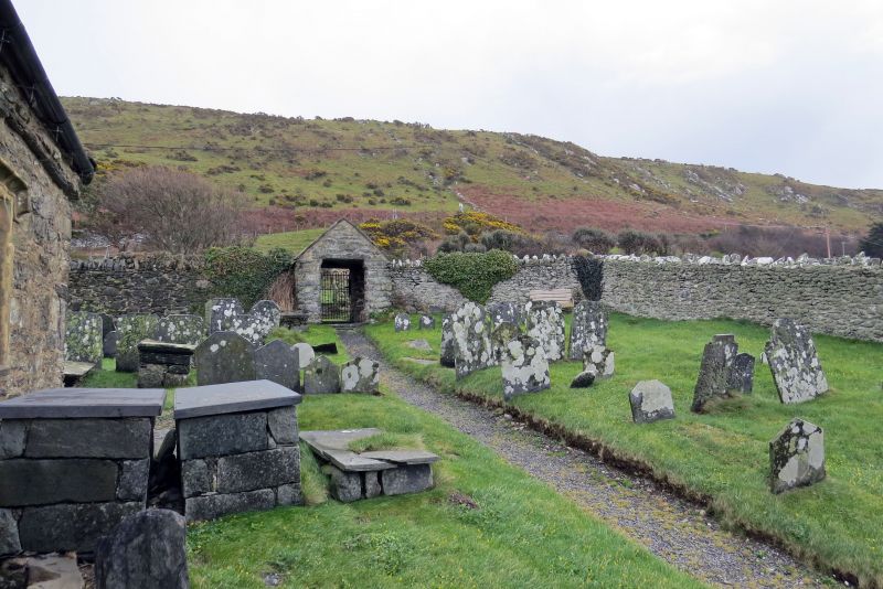
Location: Enclosing a rectangular churchyard, with lych gate towards the NE corner.

County: Gwynedd

Community: Llangelynin (Llangelynnin)

Community: Llangelynin

Traditional County: Merionethshire

Tagged with: Lychgate

Find accommodation in
Llwyngwril

History

An inscribed stone in the gable of the lych gate records the rebuilding of the walls by public subscription in 1884. The lych gate itself, however, is of earlier character and was probably only restored at this time.

Exterior

The churchyard is on a sloping site and has coped rubble walls. On the W side the wall acts as a retaining wall against the steep bank and part of its coping has fallen. The gabled lych gate is of rubble stone with slate roof behind coped gables. Entrances have lintels and on the outer side an iron gate. The interior has a simple timber roof construction, and benches built into side walls.

Reasons for Listing

Listed for their special historical interest as features of traditional character which are an integral part of the context of the church of St Celynin.

External Links

External links are from the relevant listing authority and, where applicable, Wikidata. Wikidata IDs may be related buildings as well as this specific building. If you want to add or update a link, you will need to do so by editing the Wikidata entry.

Recommended Books

Other nearby listed buildings

  • I Church of St Celynin
    To the W of and below the A493 in Llangelynin hamlet. The church stands in a rectangular churchyard, and is set into the steeply sloping ground above the railway and sea.
  • II Milepost on A493
    Approximately 450m S of Llangelynin church.
  • II Milepost on A493
    Approximately 1.2km NNE of Llangelynin church.
  • II Felin Fraenan
    Approximately 1.3km SSW of Llangelynin church, reached by farm road through Cae-du on the S side of the A493 and below the embankment on the W side of the railway.
  • II Milepost on A493
    Nearly opposite Rhoslefain Farm and approximately 100m W of the road junction in Rhoslefain hamlet.
  • II Trefaes
    Set back and reached by a short farm track on the N side of the A493, approximately 0.7km E of Rhoslefain hamlet.
  • II Cow house S of Trefaes
    To the S of the house and on the W side of the track leading up to the house.
  • II Multi-purpose farm buildings at Trefaes Farm
    To the NE of the house and forming the W side of a small farmyard.

BritishListedBuildings.co.uk is an independent online resource and is not associated with any government department. All government data published here is used under licence. Please do not contact BritishListedBuildings.co.uk for any queries related to any individual listed building, planning permission related to listed buildings or the listing process itself.

British Listed Buildings is a Good Stuff website.