History in Structure

Pont Trawsfynydd

A Grade II Listed Building in Trawsfynydd, Gwynedd

More Photos »
Approximate Location Map
Large Map »

Coordinates

Latitude: 52.8972 / 52°53'49"N

Longitude: -3.9195 / 3°55'10"W

OS Eastings: 270977

OS Northings: 335026

OS Grid: SH709350

Mapcode National: GBR 5Z.PGCR

Mapcode Global: WH55W.RFST

Plus Code: 9C4RV3WJ+V6

Entry Name: Pont Trawsfynydd

Listing Date: 28 April 1952

Last Amended: 27 February 2004

Grade: II

Source: Cadw

Source ID: 4780

Building Class: Transport

ID on this website: 300004780

Location: Spanning the Afon Prysor at the S end of the village of Maentwrog and carrying Fronwynion Street, which leads into the village directly off the A470.

County: Gwynedd

Community: Trawsfynydd

Community: Trawsfynydd

Built-Up Area: Trawsfynydd

Traditional County: Merionethshire

Tagged with: Bridge Road bridge

Find accommodation in
Trawsfynydd

History

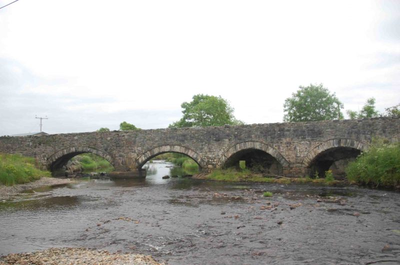
Probably early C19 road bridge.

Exterior

Road bridge built of local stone. Comprised of 4 segmental arches with dripcourses; cutwater of large stones between the 2 easternmost arches. Low parapet wall with stone slab coping.

Reasons for Listing

Included as a good early C19 road bridge.

External Links

External links are from the relevant listing authority and, where applicable, Wikidata. Wikidata IDs may be related buildings as well as this specific building. If you want to add or update a link, you will need to do so by editing the Wikidata entry.

Recommended Books

Other nearby listed buildings

  • II Milepost by Fron-oleu
    Set alongside the E side of the A470 S of Fron-oleu; to S of the village of Trawsfynydd
  • II Capel Moriah Fro
    In a prominent location, within a railed enclosure, raised above the W side of Pen y Garreg Street in the centre of the village of Trawsfynydd.
  • II Statue of Hedd Wyn
    In a slightly elevated position at the W side of Pen y Garreg Street, in the centre of the village of Trawsfynydd.
  • II Church of St Madryn
    Within a walled churchyard which has a lychgate to SW; at the NW side of the square along Church Street.
  • II White Lion Inn
    Set alongside the E side of the Pen y Garreg Street leading N out of the village of Trawsfynydd.
  • II Hayban and cowhouse at Berth-ddu
    Close to the west side of the A470, to the NE of the house at Berth-ddu, detached from the main farmyard.
  • II Outbuilding at Berth-ddu
    Between the house and the detached cow-house and haybarn, close to the west side of the A470, and built against sloping ground.
  • II Berth-ddu
    On the west side of the A470 between Trawsfynydd and Bronaber, about 1km south of Llyn Trawfynydd. The house is to the SE of its farmyard, and faces away from it, in a small enclosed garden

BritishListedBuildings.co.uk is an independent online resource and is not associated with any government department. All government data published here is used under licence. Please do not contact BritishListedBuildings.co.uk for any queries related to any individual listed building, planning permission related to listed buildings or the listing process itself.

British Listed Buildings is a Good Stuff website.