Latitude: 52.9025 / 52°54'8"N
Longitude: -3.9234 / 3°55'24"W
OS Eastings: 270730
OS Northings: 335624
OS Grid: SH707356
Mapcode National: GBR 5Z.P1G7
Mapcode Global: WH55W.P9XR
Plus Code: 9C4RW32G+XM
Entry Name: Capel Moriah Fro
Listing Date: 27 February 2004
Last Amended: 27 February 2004
Grade: II
Source: Cadw
Source ID: 82534
Building Class: Religious, Ritual and Funerary
Also known as: Moreia Chapel
ID on this website: 300082534
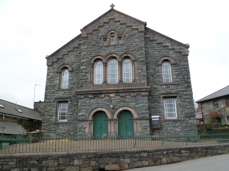
Location: In a prominent location, within a railed enclosure, raised above the W side of Pen y Garreg Street in the centre of the village of Trawsfynydd.
County: Gwynedd
Community: Trawsfynydd
Community: Trawsfynydd
Built-Up Area: Trawsfynydd
Traditional County: Merionethshire
Tagged with: Chapel
Late C19 chapel. Built to replace an earlier chapel on the site, itself rebuilt in 1839, recorded on a reset slate tablet set into the wall of the chapel yard .
Romanesque style chapel. Built of grey rock-faced snecked masonry with pale freestone dressings; slate roof with shallow stone parapet copings and fleur de lys finials. Gabled entrance elevation has stepped decoration and an advanced centre which has paired round headed arched doorways with flanking Romanesque columns; triple arched window at first floor level over a moulded corbelled course, articulated by columns with Romanesque capitals and a small Venetian window in the apex. In the flanking outer bays, there is a round-headed window over square-headed window; the side elevations have square-headed ground and first floor windows to each of 5 bays. All windows are modern replacements of the original margin paned lights. The rear elevation is rendered and has scattered modern fenestration.
Ambitiously scaled C19 chapel on an important site in the village centre.
External links are from the relevant listing authority and, where applicable, Wikidata. Wikidata IDs may be related buildings as well as this specific building. If you want to add or update a link, you will need to do so by editing the Wikidata entry.


Other nearby listed buildings