History in Structure

Milepost by Fron-oleu

A Grade II Listed Building in Trawsfynydd, Gwynedd

More Photos »
Approximate Location Map
Large Map »

Coordinates

Latitude: 52.8962 / 52°53'46"N

Longitude: -3.9178 / 3°55'4"W

OS Eastings: 271085

OS Northings: 334921

OS Grid: SH710349

Mapcode National: GBR 5Z.PNS4

Mapcode Global: WH55W.SGKJ

Plus Code: 9C4RV3WJ+FV

Entry Name: Milepost by Fron-oleu

Listing Date: 27 February 2004

Last Amended: 27 February 2004

Grade: II

Source: Cadw

Source ID: 82538

Building Class: Transport

ID on this website: 300082538

Location: Set alongside the E side of the A470 S of Fron-oleu; to S of the village of Trawsfynydd

County: Gwynedd

Community: Trawsfynydd

Community: Trawsfynydd

Traditional County: Merionethshire

Tagged with: Milestone

Find accommodation in
Trawsfynydd

History

Probably mid C19 milepost. Merioneth was the last of the Welsh counties to have turnpike roads and it was at a county meeting in Dolgellau in 1775 that it was resolved to convert the principal tracks of the county into turnpikes, in partnership with Caernarfonshire. By the end of the C18 most of the existing roads had been brought under the Trust under the Merioneth Turnpike Act of 1777 and the line of the modern road from Maentwrog to Dolgellau more or less follows the line of the early turnpike and was certainly in place by the time of the Tithe Map of the parish, 1849.

Exterior

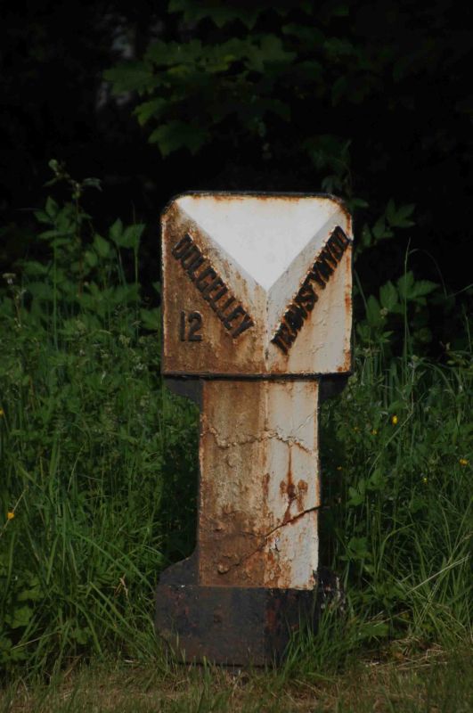
Cast iron milepost with a triangular profile, wider at the top with a raking head and facing panels which bear the names and distances: DOLGELLEY / 12 on the left hand face and TRAWSFYNYDD on the right.

Reasons for Listing

Included as a well preserved C19 milepost, one of a series along the A470.

External Links

External links are from the relevant listing authority and, where applicable, Wikidata. Wikidata IDs may be related buildings as well as this specific building. If you want to add or update a link, you will need to do so by editing the Wikidata entry.

Recommended Books

Other nearby listed buildings

  • II Pont Trawsfynydd
    Spanning the Afon Prysor at the S end of the village of Maentwrog and carrying Fronwynion Street, which leads into the village directly off the A470.
  • II Capel Moriah Fro
    In a prominent location, within a railed enclosure, raised above the W side of Pen y Garreg Street in the centre of the village of Trawsfynydd.
  • II Statue of Hedd Wyn
    In a slightly elevated position at the W side of Pen y Garreg Street, in the centre of the village of Trawsfynydd.
  • II Hayban and cowhouse at Berth-ddu
    Close to the west side of the A470, to the NE of the house at Berth-ddu, detached from the main farmyard.
  • II Church of St Madryn
    Within a walled churchyard which has a lychgate to SW; at the NW side of the square along Church Street.
  • II White Lion Inn
    Set alongside the E side of the Pen y Garreg Street leading N out of the village of Trawsfynydd.
  • II Outbuilding at Berth-ddu
    Between the house and the detached cow-house and haybarn, close to the west side of the A470, and built against sloping ground.
  • II Berth-ddu
    On the west side of the A470 between Trawsfynydd and Bronaber, about 1km south of Llyn Trawfynydd. The house is to the SE of its farmyard, and faces away from it, in a small enclosed garden

BritishListedBuildings.co.uk is an independent online resource and is not associated with any government department. All government data published here is used under licence. Please do not contact BritishListedBuildings.co.uk for any queries related to any individual listed building, planning permission related to listed buildings or the listing process itself.

British Listed Buildings is a Good Stuff website.