Approximate Location Map
Large Map »
Latitude: 53.3111 / 53°18'39"N
Longitude: -4.221 / 4°13'15"W
OS Eastings: 252123
OS Northings: 381651
OS Grid: SH521816
Mapcode National: GBR HMYY.H79
Mapcode Global: WH53T.418G
Plus Code: 9C5Q8Q6H+CH
Entry Name: Croes Wion
Listing Date: 12 May 1970
Last Amended: 27 August 2002
Grade: II
Source: Cadw
Source ID: 5379
Building Class: Religious, Ritual and Funerary
ID on this website: 300005379
Location: In a walled enclosure at the W side of the A5025 on the S approach to the village of Benllech.
County: Isle of Anglesey
Community: Llanfair-Mathafarn-Eithaf
Community: Llanfair-Mathafarn-Eithaf
Locality: Benllech
Traditional County: Anglesey
Tagged with: Architectural structure
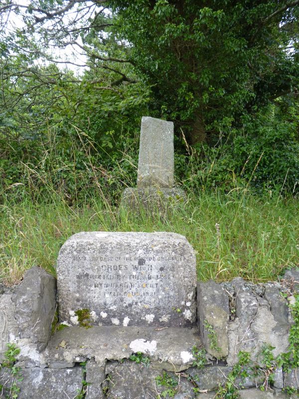
Medieval cross. Croes Wion was noted as the site of a meeting place as long ago as 1414, being the site of 'Y Farchnad Fawr' or the 'big market', which drew crowds from the surrounding districts who would travel by land and sea to gather at the site.
The various reports in the Transactions of the Anglesey Antiquarian Society show a well documented process by which the base of the cross (once forming part of the wall on the opposite side of the road to it's current position), was removed from Plas Goronwy Isaf (aka Plas Gwion) where it had been used as a hearthstone, to it's present site where "it would be an object of great interest to the vast number of passers by". The re-erection of the cross was first mooted in 1913, but the next report of the Committee in 1920 records that work was delayed due to the war and that Mr H Hughes FSA had prepared a scheme and plan, but the Committee proposed that work be deferred. In 1921 the Committee was prepared to donate £10 towards the cost of the work (estimated at £15) provided the balance be found locally, and by 1922 the Committee was glad to announce the cross set up and walled in @ £15-18s(£15.90), £7-1s-6d(£7.08) raised locally and the balance paid by the Society. In 1925 the Committee decided that a stone be set up in front of the cross to bear the inscription 'Shaft and base of Croes Wion, re-erected by the Anglesey Antiquarian Society and Field Club, 1921.'
Medieval base and lower part of cross of rough gritstone.
Listed as the remains of a Medieval Cross which is of local historic interest.
External links are from the relevant listing authority and, where applicable, Wikidata. Wikidata IDs may be related buildings as well as this specific building. If you want to add or update a link, you will need to do so by editing the Wikidata entry.


Other nearby listed buildings
