Approximate Location Map
Large Map »
Latitude: 51.6901 / 51°41'24"N
Longitude: -4.8294 / 4°49'45"W
OS Eastings: 204533
OS Northings: 202831
OS Grid: SN045028
Mapcode National: GBR GB.SL39
Mapcode Global: VH2PJ.7SR7
Plus Code: 9C3QM5RC+27
Entry Name: Old Mortuary Chapel
Listing Date: 14 May 1970
Last Amended: 6 February 1997
Grade: I
Source: Cadw
Source ID: 5945
Building Class: Religious, Ritual and Funerary
ID on this website: 300005945
Location: Within St Mary's Churchyard, about 30 m NW of the Church.
County: Pembrokeshire
Town: Tenby
Community: Carew (Caeriw)
Community: Carew
Locality: Carew Cheriton
Traditional County: Pembrokeshire
Tagged with: Chapel
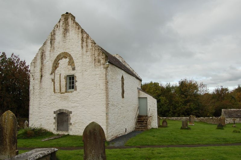
A mortuary chapel, probably of the C14, traditionally known locally as 'the Oratory'. It was later used as a school. It has a vaulted undercroft which was originally a charnel house, but in which paupers were later lodged. Two female paupers were the last occupants in c.1840. The undercroft is now used as a store-room.
The Chapel is first known to have been converted to a school in 1625. It was still in this use in 1833 when there were 50 day-school children and 60 to 70 Sunday-school children enrolled. In 1842 it is described as 'used as a Sunday-school and vestry room'. In 1846 the day-school was reformed as a National school supported by the Vicar, with 116 children enrolled and taught by the monitorial system. The school was briefly held elsewhere, but soon returned to the old chapel. It remained until a purpose-built school in the village was established in 1872. The chapel now serves as a parish meeting-room and a Sunday-school is still held there.
A large free-standing chapel on a vaulted undercroft. Rubble masonry in local limestone. Slate roof with an upstanding parapet at the verges. The entrance to the undercroft is at the W gable, and there are bone-holes at N, E and S. The ones at N and S are in their original state, that to the E is concealed behind a mural monument. The entrance to the chapel is by an external flight of steps in the N side, the door being in the NW corner. Part of the stone tracery and the dressed arch of the blocked E window survive.
In the chapel fragments of the original three-light E window remain, partly blocked by a later smaller window and a fireplace. The flue from the fireplace appears to occupy part of the old window void. A piscina with a trefoiled ogee-headed hood is in the SE corner. A modern window is fitted into the original lancet opening in the N wall. There is a water-stoup in a recess with a simple pointed head beside the entrance door. The roof is divided by six trusses, with a half-bay at each end. The roof span is 5.4 m. There are high collar beams and there are two rows of purlins at each side. The collar beams are cambered and tenoned into the principals.
The undercroft has an elliptical vault in rubble limestone, of about 5 m span with a rise of about 1.5 m, without ribs. The N and S walls upon which it bears are about 1.2 m in thickness.
The monument built into the exterior of the E wall is to John Relly, d.1777, a prominent early leader of the Calvinist Methodist movement.
Listed Grade I as a well preserved and rare example of a mortuary chapel with additional social history interest as a schoolroom and a lodging for paupers.
External links are from the relevant listing authority and, where applicable, Wikidata. Wikidata IDs may be related buildings as well as this specific building. If you want to add or update a link, you will need to do so by editing the Wikidata entry.


Other nearby listed buildings
