History in Structure

Parish Church of St Teilo

A Grade II Listed Building in Narberth (Arberth), Pembrokeshire

More Photos »
Approximate Location Map
Large Map »

Coordinates

Latitude: 51.7966 / 51°47'47"N

Longitude: -4.7168 / 4°43'0"W

OS Eastings: 212755

OS Northings: 214375

OS Grid: SN127143

Mapcode National: GBR CX.Y2NV

Mapcode Global: VH2P6.639K

Plus Code: 9C3QQ7WM+J7

Entry Name: Parish Church of St Teilo

Listing Date: 17 May 1988

Last Amended: 17 May 1988

Grade: II

Source: Cadw

Source ID: 6535

Building Class: Religious, Ritual and Funerary

ID on this website: 300006535

Location: In a rectangular churchyard on the left at the end of a lane leading off the B4314 and adjoining Crinow Farm.

County: Pembrokeshire

Community: Narberth (Arberth)

Community: Narberth

Locality: Crinow

Traditional County: Pembrokeshire

Tagged with: Church building

Find accommodation in
Narberth

Exterior

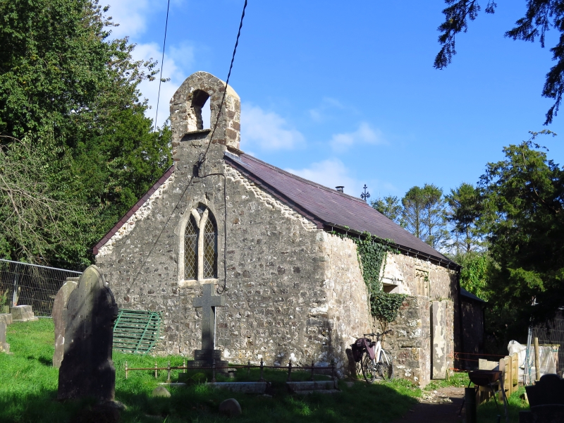
Small vernacular church of medieval origin. Aisle-less nave with narrower chancel. Random rubble masonry, widely slobbered mortar. Gabled bellcote with water tabling to W end. Moderately pitched slate roofs, lower and gentler pitch to chancel.
Y-tracery to pointed W window. Cambered arch to gabled stone S porch, slate roof. Gothic panelled inner door. C19, 3 light panelled tracery window to nave; similar to N side and E end. Modern brick boilerhouse by N angle of Chancel.

Boarded roof, plaster walls. C19 wall monuments to Eaton Family of Parc Glas. Slab to Richard Mathias 1763 set to N wall. Four centred chancel arch.

External Links

External links are from the relevant listing authority and, where applicable, Wikidata. Wikidata IDs may be related buildings as well as this specific building. If you want to add or update a link, you will need to do so by editing the Wikidata entry.

Recommended Books

Other nearby listed buildings

  • II Parc Glas
    At the end of a driveway which bridges a sunken track off the right side of the lane leading off the B4314.
  • II Crinow and Lampeter Velfrey Parish Boundary Stone
    At N side of the unclassified road on the parish boundary near Clyn Pattel.
  • II Parish Boundary Stone
    Set on the roadside up against the right hand gatepier of a fieldgate opposite the entrance to Blackaldern.
  • II Blackaldern
    Situated at the end of a long drive leading from the B4314 some 300 yds SE of the junction with Kiln Park Road.
  • II Milestone
    In the verge set up against the hedge bank some 70 yds SE of the junction with Kiln Park Road.
  • II Coach House at Blackaldern
    Situated beyond the house at the end of a long drive leading from the B4314 some 300 yds SE of the junction with Kiln Park Road.
  • II Stable adjoining Greenway Farm
    Gable end on to the road 300 yds NW from the junction with Kiln Park Road.
  • II Greenway Farm
    Gable end to the roadside 300 yds NW from the junction with Kiln Park Road.

BritishListedBuildings.co.uk is an independent online resource and is not associated with any government department. All government data published here is used under licence. Please do not contact BritishListedBuildings.co.uk for any queries related to any individual listed building, planning permission related to listed buildings or the listing process itself.

British Listed Buildings is a Good Stuff website.